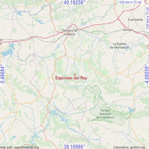
Espinoso del Rey geodata
Espinoso del Rey (Castille-La Mancha) is a seat of a third-order administrative division; located in Spain in Europe/Madrid (GMT+2) time zone. With population of 599 people, there are 3614 cities with bigger population in this country. Compared to other cities in Spain, 75% of cities are located further ↑North; 69.5% of cities are located further →East and 57% of cities have lower elevation than Espinoso del Rey. Note1
Administrative division(s):
- Level 1: Castille-La Mancha
- Level 2: Province of Toledo
- Level 3: Espinoso del Rey


Espinoso del Rey GPS coordinates[2]
39° 39' 11.988" North, 4° 47' 1.356" West
| Map corner | latitude | longitude |
|---|---|---|
| Upper-left | 40.19256°, | -5.48684° |
| Center: | 39.65333°, | -4.78371° |
| Lower-right: | 39.10986°, | -4.08059° |
| Map W x H: | 120.4×120.4 km | = 74.8×74.8mi |
| max Lat: | 43.74134° ⇑75% North |
| Espinoso del Rey: | 39.65333° |
| min Lat: | ⇓25% South 27.64134° |
| min Long | Espinoso del Re | max Long |
| -18.00367° | -4.78371° | 4.2899° |
| W 30.5%⇐ | ⇒69.5% E |
Elevation
Elevation of Espinoso del Rey is 723 m = 2372 ft, and this is 125 m = 410 ft above average elevation for this country.
| Max E: |
1682 m = 5518 ft | 43% |
| Espinoso del Rey | 723 m 2372 ft | |
| Avg. | 598 m = 1962 ft | |
Min E: |
0 m = 0 ft | 57% |
See also: Spain elevation on elevation.city.
Geographical zone
Espinoso del Rey is located in North temperate zone (between Tropic of Cancer and the Arctic Circle). Distance of this Northern Tropic circle is 1803.1 km =1120.4 mi to South.| Distance of | km | miles | from Espinoso del Rey |
|---|---|---|---|
| North Pole | 5598 | 3478.4 | to North |
| Arctic Circle | 2992.1 | 1859.2 | to North |
| Tropic Cancer | 1803.1 | 1120.4 | to South |
| Equator | 4409 | 2739.6 | to South |


Nearby cities:
15 places around Espinoso del Rey: (largest is in red/bold)
• Aldeanueva de Barbarroya
23.6 km =14.7 mi,  299°
299°
• Anchuras
19.7 km =12.2 mi,  192°
192°
• Belvis de la Jara
18.3 km =11.4 mi,  309°
309°
• Hontanar
25 km =15.5 mi,  100°
100°
• La Nava de Ricomalillo
17.8 km =11.1 mi,  268°
268°
• Las Herencias
26.7 km =16.6 mi,  333°
333°
• Los Navalmorales
14.5 km =9 mi,  56°
56°
• Los Navalucillos
12.2 km =7.6 mi,  83°
83°
• Rosalejo
26.4 km =16.4 mi,  203°
203°
• San Bartolomé de las Abiertas
20.4 km =12.7 mi,  15°
15°
• San Martín de Pusa
19.5 km =12.1 mi,  41°
41°
• Santa Ana de Pusa
13.7 km =8.5 mi,  27°
27°
• Sevilleja de la Jara
17.7 km =11 mi,  240°
240°
• Torrecilla de la Jara
5.8 km =3.6 mi,  10°
10°
• Villarejo de Montalbán
22.1 km =13.7 mi,  54°
54°
Sources, notices
• [Note1] Compared only with cities in Spain existing in our database
• [Src1] Map data: © OpenStreetMap contributors (CC-BY-SA)
• [Src2] Other city data from geonames.org with taken over terms of usage.
• [Src3] Geographical zone / Annual Mean Temperature by Robert A. Rohde @ Wikipedia
