Anchuras geodata
Anchuras (Castille-La Mancha) is a seat of a third-order administrative division; located in Spain in Europe/Madrid (GMT+2) time zone. In our database, there are 6762 cities with bigger population. Compared to other cities in Spain, 77.1% of cities are located further ↑North; 70.1% of cities are located further →East and 58.5% of cities have higher elevation than Anchuras. Note1
Administrative division(s):
- Level 1: Castille-La Mancha
- Level 2: Provincia de Ciudad Real
- Level 3: Anchuras


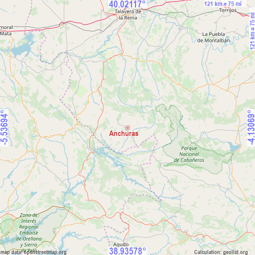
Anchuras GPS coordinates[2]
39° 28' 50.124" North, 4° 50' 1.716" West
| Map corner | latitude | longitude |
|---|---|---|
| Upper-left | 40.02117°, | -5.53694° |
| Center: | 39.48059°, | -4.83381° |
| Lower-right: | 38.93578°, | -4.13069° |
| Map W x H: | 120.7×120.7 km | = 75×75mi |
| max Lat: | 43.74134° ⇑77.1% North |
| Anchuras: | 39.48059° |
| min Lat: | ⇓22.9% South 27.64134° |
| min Long | Anchuras | max Long |
| -18.00367° | -4.83381° | 4.2899° |
| W 29.9%⇐ | ⇒70.1% E |
Elevation
Elevation of Anchuras is 548 m = 1798 ft, and this is 50 m = 164 ft below average elevation for this country.
| Max E: |
1682 m = 5518 ft | 58.5% |
| Avg. | 598 m = 1962 ft | |
| Anchuras | 548 m = 1798 ft | |
Min E: |
0 m = 0 ft | 41.5% |
See also: Spain elevation on elevation.city.
Geographical zone
Anchuras is located in North temperate zone (between Tropic of Cancer and the Arctic Circle). Distance of this Northern Tropic circle is 1783.9 km =1108.5 mi to South.| Distance of | km | miles | from Anchuras |
|---|---|---|---|
| North Pole | 5617.2 | 3490.4 | to North |
| Arctic Circle | 3011.3 | 1871.1 | to North |
| Tropic Cancer | 1783.9 | 1108.5 | to South |
| Equator | 4389.8 | 2727.7 | to South |


Nearby cities:
15 places around Anchuras: (largest is in red/bold)
• Aldeanueva de San Bartolomé
29.5 km =18.3 mi,  305°
305°
• Castilblanco
31 km =19.3 mi,  225°
225°
• Espinoso del Rey
19.7 km =12.2 mi,  12°
12°
• Helechosa
19.8 km =12.3 mi,  198°
198°
• Hontanar
32.4 km =20.1 mi,  63°
63°
• La Nava de Ricomalillo
23.1 km =14.4 mi,  324°
324°
• Los Navalmorales
31.8 km =19.8 mi,  31°
31°
• Los Navalucillos
26.4 km =16.4 mi,  38°
38°
• Mohedas de la Jara
29.8 km =18.5 mi,  297°
297°
• Navas de Estena
26.8 km =16.7 mi,  86°
86°
• Puerto de San Vicente
24.5 km =15.2 mi,  281°
281°
• Rosalejo
8 km =5 mi, 232°
• Sevilleja de la Jara
15.3 km =9.5 mi, 313°
• Torrecilla de la Jara
25.4 km =15.8 mi, 12°
• Villarta de los Montes
29.9 km =18.6 mi,  173°
173°
Sources, notices
• [Note1] Compared only with cities in Spain existing in our database
• [Src1] Map data: © OpenStreetMap contributors (CC-BY-SA)
• [Src2] Other city data from geonames.org with taken over terms of usage.
• [Src3] Geographical zone / Annual Mean Temperature by Robert A. Rohde @ Wikipedia
