Robledollano geodata
Robledollano (Extremadura) is a seat of a third-order administrative division; located in Spain in Europe/Madrid (GMT+2) time zone. With population of 380 people, there are 4207 cities with bigger population in this country. Compared to other cities in Spain, 75.7% of cities are located further ↑North; 78.8% of cities are located further →East and 55.6% of cities have lower elevation than Robledollano. Note1
Administrative division(s):
- Level 1: Extremadura
- Level 2: Provincia de Cáceres
- Level 3: Robledollano


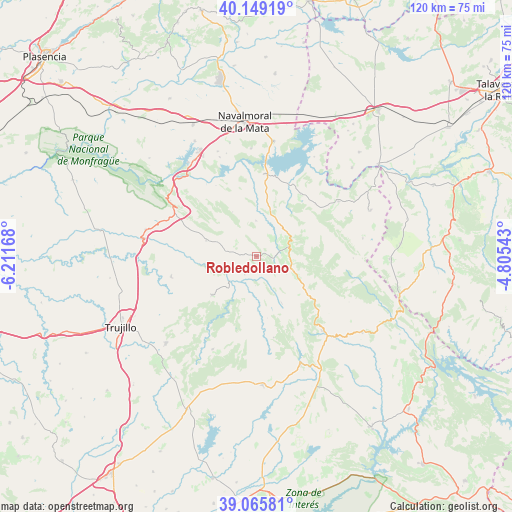
Robledollano GPS coordinates[2]
39° 36' 34.632" North, 5° 30' 30.78" West
| Map corner | latitude | longitude |
|---|---|---|
| Upper-left | 40.14919°, | -6.21168° |
| Center: | 39.60962°, | -5.50855° |
| Lower-right: | 39.06581°, | -4.80543° |
| Map W x H: | 120.5×120.5 km | = 74.9×74.9mi |
| max Lat: | 43.74134° ⇑75.7% North |
| Robledollano: | 39.60962° |
| min Lat: | ⇓24.3% South 27.64134° |
| min Long | Robledollano | max Long |
| -18.00367° | -5.50855° | 4.2899° |
| W 21.2%⇐ | ⇒78.8% E |
Elevation
Elevation of Robledollano is 713 m = 2339 ft, and this is 115 m = 377 ft above average elevation for this country.
| Max E: |
1682 m = 5518 ft | 44.4% |
| Robledollano | 713 m 2339 ft | |
| Avg. | 598 m = 1962 ft | |
Min E: |
0 m = 0 ft | 55.6% |
See also: Spain elevation on elevation.city.
Geographical zone
Robledollano is located in North temperate zone (between Tropic of Cancer and the Arctic Circle). Distance of this Northern Tropic circle is 1798.3 km =1117.4 mi to South.| Distance of | km | miles | from Robledollano |
|---|---|---|---|
| North Pole | 5602.9 | 3481.5 | to North |
| Arctic Circle | 2997 | 1862.2 | to North |
| Tropic Cancer | 1798.3 | 1117.4 | to South |
| Equator | 4404.2 | 2736.6 | to South |


Nearby cities:
15 places around Robledollano: (largest is in red/bold)
• Aldeacentenera
13.8 km =8.6 mi,  228°
228°
• Berzocana
19.6 km =12.2 mi,  168°
168°
• Bohonal de Ibor
19.6 km =12.2 mi,  5°
5°
• Cabañas del Castillo
6.9 km =4.3 mi,  182°
182°
• Campillo de Deleitosa
11.8 km =7.3 mi,  331°
331°
• Castañar de Ibor
8.1 km =5 mi,  75°
75°
• Deleitosa
12.3 km =7.6 mi,  287°
287°
• Fresnedoso de Ibor
8.3 km =5.2 mi,  359°
359°
• Garvín
18.5 km =11.5 mi,  48°
48°
• Higuera
18.7 km =11.6 mi,  313°
313°
• Mesas de Ibor
16.6 km =10.3 mi,  348°
348°
• Navalvillar de Ibor
8.6 km =5.3 mi,  109°
109°
• Navezuelas
12.7 km =7.9 mi,  151°
151°
• Peraleda de San Román
17.9 km =11.1 mi,  35°
35°
• Valdecañas de Tajo
19.2 km =11.9 mi, 330°
Sources, notices
• [Note1] Compared only with cities in Spain existing in our database
• [Src1] Map data: © OpenStreetMap contributors (CC-BY-SA)
• [Src2] Other city data from geonames.org with taken over terms of usage.
• [Src3] Geographical zone / Annual Mean Temperature by Robert A. Rohde @ Wikipedia
