Petra geodata
Petra (Balearic Islands) is a seat of a third-order administrative division; located in Spain in Europe/Madrid (GMT+2) time zone. With population of 2,707 people, there are 1814 cities with bigger population in this country. Compared to other cities in Spain, 75.6% of cities are located further ↑North; 99.4% of cities are located further ←West and 87.4% of cities have higher elevation than Petra. Note1


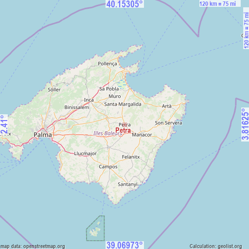
Petra GPS coordinates[2]
39° 36' 48.636" North, 3° 6' 47.232" East
| Map corner | latitude | longitude |
|---|---|---|
| Upper-left | 40.15305°, | 2.41° |
| Center: | 39.61351°, | 3.11312° |
| Lower-right: | 39.06973°, | 3.81625° |
| Map W x H: | 120.5×120.5 km | = 74.9×74.9mi |
| max Lat: | 43.74134° ⇑75.6% North |
| Petra: | 39.61351° |
| min Lat: | ⇓24.4% South 27.64134° |
| min Long | Petra | max Long |
| -18.00367° | 3.11312° | 4.2899° |
| W 99.4%⇐ | ⇒0.59999999999999% E |
Elevation
Elevation of Petra is 103 m = 338 ft, and this is 495 m = 1624 ft below average elevation for this country.
| Max E: |
1682 m = 5518 ft | 87.4% |
| Avg. | 598 m = 1962 ft | |
| Petra | 103 m = 338 ft | |
Min E: |
0 m = 0 ft | 12.6% |
See also: Spain elevation on elevation.city.
Geographical zone
Petra is located in North temperate zone (between Tropic of Cancer and the Arctic Circle). Distance of this Northern Tropic circle is 1798.7 km =1117.7 mi to South.| Distance of | km | miles | from Petra |
|---|---|---|---|
| North Pole | 5602.5 | 3481.2 | to North |
| Arctic Circle | 2996.6 | 1862 | to North |
| Tropic Cancer | 1798.7 | 1117.7 | to South |
| Equator | 4404.6 | 2736.9 | to South |


Nearby cities:
15 places around Petra: (largest is in red/bold)
• Ariany
4.1 km =2.5 mi,  356°
356°
• Costitx
14.8 km =9.2 mi,  288°
288°
• Felanitx
16.3 km =10.1 mi,  169°
169°
• Lloret de Vistalegre
11.8 km =7.3 mi,  272°
272°
• Llubí
13.2 km =8.2 mi,  316°
316°
• Manacor
9.6 km =6 mi,  120°
120°
• Maria de la Salut
6.5 km =4 mi,  328°
328°
• Montuïri
12.4 km =7.7 mi,  245°
245°
• Muro
14.5 km =9 mi,  340°
340°
• Porreres
13.5 km =8.4 mi,  215°
215°
• Sant Joan
6.6 km =4.1 mi, 253°
• Sant Llorenç des Cardassar
14.6 km =9.1 mi,  91°
91°
• Santa Margalida
9.8 km =6.1 mi,  354°
354°
• Sineu
9.4 km =5.8 mi, 290°
• Vilafranca de Bonany
5.4 km =3.4 mi,  203°
203°
Sources, notices
• [Note1] Compared only with cities in Spain existing in our database
• [Src1] Map data: © OpenStreetMap contributors (CC-BY-SA)
• [Src2] Other city data from geonames.org with taken over terms of usage.
• [Src3] Geographical zone / Annual Mean Temperature by Robert A. Rohde @ Wikipedia
