Maria de la Salut geodata
Maria de la Salut (Balearic Islands) is a seat of a third-order administrative division; located in Spain in Europe/Madrid (GMT+2) time zone. With population of 2,118 people, there are 2088 cities with bigger population in this country. Compared to other cities in Spain, 74.9% of cities are located further ↑North; 99.2% of cities are located further ←West and 86.6% of cities have higher elevation than Maria de la Salut. Note1
Administrative division(s):
- Level 1: Balearic Islands
- Level 2: Illes Balears
- Level 3: Maria de la Salut


Maria de la Salut GPS coordinates[2]
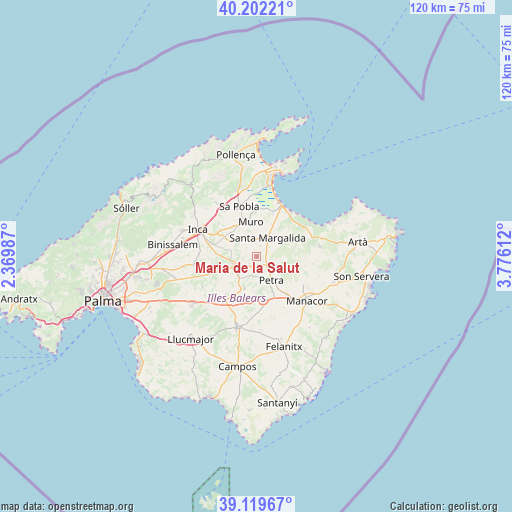
39° 39' 47.016" North, 3° 4' 22.8" East
| Map corner | latitude | longitude |
|---|---|---|
| Upper-left | 40.20221°, | 2.36987° |
| Center: | 39.66306°, | 3.073° |
| Lower-right: | 39.11967°, | 3.77612° |
| Map W x H: | 120.4×120.4 km | = 74.8×74.8mi |
| max Lat: | 43.74134° ⇑74.9% North |
| Maria de la Salut: | 39.66306° |
| min Lat: | ⇓25.1% South 27.64134° |
| min Long | Maria de la Sal | max Long |
| -18.00367° | 3.073° | 4.2899° |
| W 99.2%⇐ | ⇒0.8% E |
Elevation
Elevation of Maria de la Salut is 114 m = 374 ft, and this is 484 m = 1588 ft below average elevation for this country.
| Max E: |
1682 m = 5518 ft | 86.6% |
| Avg. | 598 m = 1962 ft | |
| Maria de la Salut | 114 m = 374 ft | |
Min E: |
0 m = 0 ft | 13.4% |
See also: Spain elevation on elevation.city.
Geographical zone
Maria de la Salut is located in North temperate zone (between Tropic of Cancer and the Arctic Circle). Distance of this Northern Tropic circle is 1804.2 km =1121.1 mi to South.| Distance of | km | miles | from Maria de la Salut |
|---|---|---|---|
| North Pole | 5596.9 | 3477.8 | to North |
| Arctic Circle | 2991.1 | 1858.6 | to North |
| Tropic Cancer | 1804.2 | 1121.1 | to South |
| Equator | 4410.1 | 2740.3 | to South |


Nearby cities:
15 places around Maria de la Salut: (largest is in red/bold)
• Ariany
3.5 km =2.2 mi,  113°
113°
• Búger
13 km =8.1 mi,  324°
324°
• Can Picafort
13.4 km =8.3 mi,  31°
31°
• Costitx
10.6 km =6.6 mi,  266°
266°
• Lloret de Vistalegre
9.8 km =6.1 mi,  239°
239°
• Llubí
7 km =4.3 mi,  305°
305°
• Montuïri
13.2 km =8.2 mi,  216°
216°
• Muro
8.3 km =5.2 mi,  349°
349°
• Petra
6.5 km =4 mi,  148°
148°
• Sant Joan
8 km =5 mi,  201°
201°
• Santa Margalida
4.9 km =3 mi, 30°
• Sencelles
15.1 km =9.4 mi,  262°
262°
• Sineu
5.8 km =3.6 mi,  246°
246°
• Vilafranca de Bonany
10.5 km =6.5 mi,  172°
172°
• sa Pobla
12.5 km =7.8 mi,  340°
340°
Sources, notices
• [Note1] Compared only with cities in Spain existing in our database
• [Src1] Map data: © OpenStreetMap contributors (CC-BY-SA)
• [Src2] Other city data from geonames.org with taken over terms of usage.
• [Src3] Geographical zone / Annual Mean Temperature by Robert A. Rohde @ Wikipedia
