Nogales geodata
Nogales (Extremadura) is a seat of a third-order administrative division; located in Spain in Europe/Madrid (GMT+2) time zone. With population of 689 people, there are 3420 cities with bigger population in this country. Compared to other cities in Spain, 85.1% of cities are located further ↑North; 93.2% of cities are located further →East and 70.5% of cities have higher elevation than Nogales. Note1


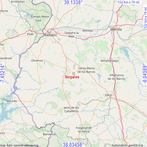
Nogales GPS coordinates[2]
38° 35' 10.644" North, 6° 44' 56.436" West
| Map corner | latitude | longitude |
|---|---|---|
| Upper-left | 39.1338°, | -7.45214° |
| Center: | 38.58629°, | -6.74901° |
| Lower-right: | 38.03458°, | -6.04589° |
| Map W x H: | 122.2×122.2 km | = 75.9×75.9mi |
| max Lat: | 43.74134° ⇑85.1% North |
| Nogales: | 38.58629° |
| min Lat: | ⇓14.9% South 27.64134° |
| min Long | Nogales | max Long |
| -18.00367° | -6.74901° | 4.2899° |
| W 6.8%⇐ | ⇒93.2% E |
Elevation
Elevation of Nogales is 373 m = 1224 ft, and this is 225 m = 738 ft below average elevation for this country.
| Max E: |
1682 m = 5518 ft | 70.5% |
| Avg. | 598 m = 1962 ft | |
| Nogales | 373 m = 1224 ft | |
Min E: |
0 m = 0 ft | 29.5% |
See also: Spain elevation on elevation.city.
Geographical zone
Nogales is located in North temperate zone (between Tropic of Cancer and the Arctic Circle). Distance of this Northern Tropic circle is 1684.5 km =1046.7 mi to South.| Distance of | km | miles | from Nogales |
|---|---|---|---|
| North Pole | 5716.7 | 3552.2 | to North |
| Arctic Circle | 3110.8 | 1933 | to North |
| Tropic Cancer | 1684.5 | 1046.7 | to South |
| Equator | 4290.4 | 2665.9 | to South |


Nearby cities:
15 places around Nogales: (largest is in red/bold)
• Almendral
7 km =4.3 mi,  296°
296°
• Barcarrota
11.8 km =7.3 mi,  227°
227°
• Corte de Peleas
17 km =10.6 mi,  23°
23°
• Entrín Bajo
15 km =9.3 mi,  11°
11°
• Feria
18.1 km =11.2 mi,  117°
117°
• La Albuera
16 km =9.9 mi,  336°
336°
• La Morera
9.5 km =5.9 mi, 118°
• La Parra
13.2 km =8.2 mi, 123°
• Salvaleón
9.1 km =5.7 mi,  200°
200°
• Salvatierra de los Barros
12 km =7.5 mi,  152°
152°
• Santa Marta
11 km =6.8 mi,  73°
73°
• Torre de Miguel Sesmero
5.5 km =3.4 mi,  311°
311°
• Valle de Matamoros
23.5 km =14.6 mi,  191°
191°
• Valverde de Leganés
22.2 km =13.8 mi, 295°
• Villalba de los Barros
21.1 km =13.1 mi,  81°
81°
Sources, notices
• [Note1] Compared only with cities in Spain existing in our database
• [Src1] Map data: © OpenStreetMap contributors (CC-BY-SA)
• [Src2] Other city data from geonames.org with taken over terms of usage.
• [Src3] Geographical zone / Annual Mean Temperature by Robert A. Rohde @ Wikipedia
