Almendral geodata
Almendral (Extremadura) is a seat of a third-order administrative division; located in Spain in Europe/Madrid (GMT+2) time zone. With population of 1,327 people, there are 2618 cities with bigger population in this country. Compared to other cities in Spain, 84.9% of cities are located further ↑North; 93.6% of cities are located further →East and 73.4% of cities have higher elevation than Almendral. Note1


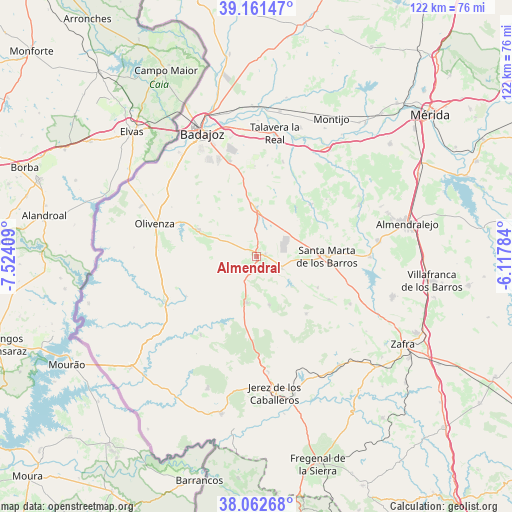
Almendral GPS coordinates[2]
38° 36' 51.048" North, 6° 49' 15.492" West
| Map corner | latitude | longitude |
|---|---|---|
| Upper-left | 39.16147°, | -7.52409° |
| Center: | 38.61418°, | -6.82097° |
| Lower-right: | 38.06268°, | -6.11784° |
| Map W x H: | 122.2×122.2 km | = 75.9×75.9mi |
| max Lat: | 43.74134° ⇑84.9% North |
| Almendral: | 38.61418° |
| min Lat: | ⇓15.1% South 27.64134° |
| min Long | Almendral | max Long |
| -18.00367° | -6.82097° | 4.2899° |
| W 6.4%⇐ | ⇒93.6% E |
Elevation
Elevation of Almendral is 325 m = 1066 ft, and this is 273 m = 896 ft below average elevation for this country.
| Max E: |
1682 m = 5518 ft | 73.4% |
| Avg. | 598 m = 1962 ft | |
| Almendral | 325 m = 1066 ft | |
Min E: |
0 m = 0 ft | 26.6% |
See also: Spain elevation on elevation.city.
Geographical zone
Almendral is located in North temperate zone (between Tropic of Cancer and the Arctic Circle). Distance of this Northern Tropic circle is 1687.6 km =1048.6 mi to South.| Distance of | km | miles | from Almendral |
|---|---|---|---|
| North Pole | 5713.6 | 3550.3 | to North |
| Arctic Circle | 3107.7 | 1931 | to North |
| Tropic Cancer | 1687.6 | 1048.6 | to South |
| Equator | 4293.5 | 2667.9 | to South |


Nearby cities:
15 places around Almendral: (largest is in red/bold)
• Alconchel
24.3 km =15.1 mi,  243°
243°
• Barcarrota
11.3 km =7 mi,  192°
192°
• Corte de Peleas
18.1 km =11.2 mi,  46°
46°
• Entrín Bajo
14.9 km =9.3 mi,  38°
38°
• Higuera de Vargas
22.9 km =14.2 mi,  215°
215°
• La Albuera
11.5 km =7.1 mi,  359°
359°
• La Morera
16.5 km =10.3 mi,  117°
117°
• La Parra
20.1 km =12.5 mi, 120°
• Nogales
7 km =4.3 mi, 116°
• Salvaleón
11.9 km =7.4 mi,  165°
165°
• Salvatierra de los Barros
18.1 km =11.2 mi,  139°
139°
• Santa Marta
16.8 km =10.4 mi,  89°
89°
• Torre de Miguel Sesmero
2.3 km =1.4 mi,  75°
75°
• Táliga
19.5 km =12.1 mi, 240°
• Valverde de Leganés
15.2 km =9.4 mi,  294°
294°
Sources, notices
• [Note1] Compared only with cities in Spain existing in our database
• [Src1] Map data: © OpenStreetMap contributors (CC-BY-SA)
• [Src2] Other city data from geonames.org with taken over terms of usage.
• [Src3] Geographical zone / Annual Mean Temperature by Robert A. Rohde @ Wikipedia
