Mocejón geodata
Mocejón (Castille-La Mancha) is a seat of a third-order administrative division; located in Spain in Europe/Madrid (GMT+2) time zone. With population of 4,449 people, there are 1394 cities with bigger population in this country. Compared to other cities in Spain, 71.1% of cities are located further ↑North; 58.4% of cities are located further →East and 63.3% of cities have higher elevation than Mocejón. Note1
Administrative division(s):
- Level 1: Castille-La Mancha
- Level 2: Province of Toledo
- Level 3: Mocejón


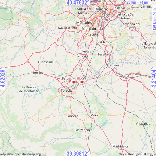
Mocejón GPS coordinates[2]
39° 56' 21.624" North, 3° 55' 1.776" West
| Map corner | latitude | longitude |
|---|---|---|
| Upper-left | 40.47632°, | -4.62029° |
| Center: | 39.93934°, | -3.91716° |
| Lower-right: | 39.39812°, | -3.21404° |
| Map W x H: | 119.9×119.9 km | = 74.5×74.5mi |
| max Lat: | 43.74134° ⇑71.1% North |
| Mocejón: | 39.93934° |
| min Lat: | ⇓28.9% South 27.64134° |
| min Long | Mocejón | max Long |
| -18.00367° | -3.91716° | 4.2899° |
| W 41.6%⇐ | ⇒58.4% E |
Elevation
Elevation of Mocejón is 483 m = 1585 ft, and this is 115 m = 377 ft below average elevation for this country.
| Max E: |
1682 m = 5518 ft | 63.3% |
| Avg. | 598 m = 1962 ft | |
| Mocejón | 483 m = 1585 ft | |
Min E: |
0 m = 0 ft | 36.7% |
See also: Spain elevation on elevation.city.
Geographical zone
Mocejón is located in North temperate zone (between Tropic of Cancer and the Arctic Circle). Distance of this Northern Tropic circle is 1834.9 km =1140.2 mi to South.| Distance of | km | miles | from Mocejón |
|---|---|---|---|
| North Pole | 5566.2 | 3458.7 | to North |
| Arctic Circle | 2960.3 | 1839.4 | to North |
| Tropic Cancer | 1834.9 | 1140.2 | to South |
| Equator | 4440.8 | 2759.4 | to South |


Nearby cities:
15 places around Mocejón: (largest is in red/bold)
• Añover de Tajo
14 km =8.7 mi,  66°
66°
• Bargas
8.8 km =5.5 mi,  271°
271°
• Cabañas de la Sagra
7.8 km =4.8 mi,  341°
341°
• Camarenilla
16.1 km =10 mi,  302°
302°
• Cobeja
10.4 km =6.5 mi,  29°
29°
• La Alameda de la Sagra
13.3 km =8.3 mi,  52°
52°
• Magán
2.7 km =1.7 mi,  333°
333°
• Nambroca
15.9 km =9.9 mi,  188°
188°
• Numancia de la Sagra
16 km =9.9 mi,  20°
20°
• Olías del Rey
6 km =3.7 mi,  275°
275°
• Pantoja
13.6 km =8.5 mi, 31°
• Recas
14.1 km =8.8 mi, 333°
• Toledo
12.7 km =7.9 mi,  224°
224°
• Villaseca de la Sagra
3.8 km =2.4 mi, 49°
• Yuncler
11.4 km =7.1 mi,  7°
7°
Sources, notices
• [Note1] Compared only with cities in Spain existing in our database
• [Src1] Map data: © OpenStreetMap contributors (CC-BY-SA)
• [Src2] Other city data from geonames.org with taken over terms of usage.
• [Src3] Geographical zone / Annual Mean Temperature by Robert A. Rohde @ Wikipedia
