Munera geodata
Munera (Castille-La Mancha) is a populated place; located in Spain in Europe/Madrid (GMT+2) time zone. With population of 3,985 people, there are 1481 cities with bigger population in this country. Compared to other cities in Spain, 80.7% of cities are located further ↑North; 61.2% of cities are located further ←West and 82.6% of cities have lower elevation than Munera. Note1
Administrative division(s):
- Level 1: Castille-La Mancha
- Level 2: Provincia de Albacete
- Level 3: Bonillo, El


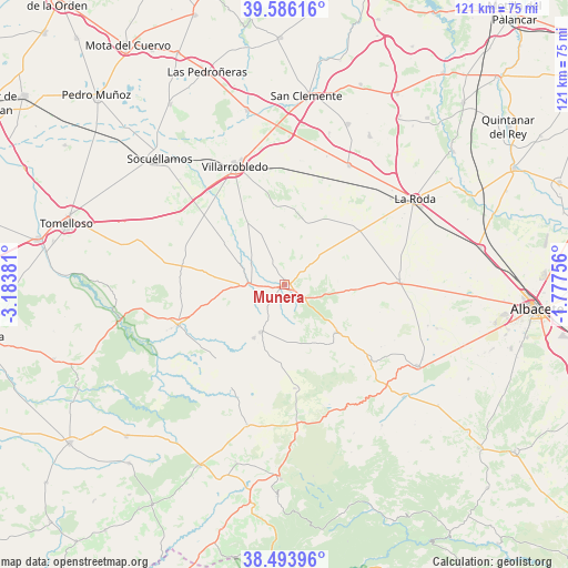
Munera GPS coordinates[2]
39° 2' 31.812" North, 2° 28' 50.448" West
| Map corner | latitude | longitude |
|---|---|---|
| Upper-left | 39.58616°, | -3.18381° |
| Center: | 39.04217°, | -2.48068° |
| Lower-right: | 38.49396°, | -1.77756° |
| Map W x H: | 121.4×121.4 km | = 75.4×75.4mi |
| max Lat: | 43.74134° ⇑80.7% North |
| Munera: | 39.04217° |
| min Lat: | ⇓19.3% South 27.64134° |
| min Long | Munera | max Long |
| -18.00367° | -2.48068° | 4.2899° |
| W 61.2%⇐ | ⇒38.8% E |
Elevation
Elevation of Munera is 923 m = 3028 ft, and this is 325 m = 1066 ft above average elevation for this country.
| Max E: |
1682 m = 5518 ft | 17.4% |
| Munera | 923 m 3028 ft | |
| Avg. | 598 m = 1962 ft | |
Min E: |
0 m = 0 ft | 82.6% |
See also: Spain elevation on elevation.city.
Geographical zone
Munera is located in North temperate zone (between Tropic of Cancer and the Arctic Circle). Distance of this Northern Tropic circle is 1735.2 km =1078.2 mi to South.| Distance of | km | miles | from Munera |
|---|---|---|---|
| North Pole | 5666 | 3520.7 | to North |
| Arctic Circle | 3060.1 | 1901.5 | to North |
| Tropic Cancer | 1735.2 | 1078.2 | to South |
| Equator | 4341.1 | 2697.4 | to South |


Nearby cities:
15 places around Munera: (largest is in red/bold)
• Balazote
33.4 km =20.8 mi,  121°
121°
• Barrax
24.1 km =15 mi,  88°
88°
• Casas de Lázaro
36.7 km =22.8 mi,  145°
145°
• Casas de los Pinos
33.8 km =21 mi,  16°
16°
• El Ballestero
22.4 km =13.9 mi,  174°
174°
• El Bonillo
11.4 km =7.1 mi,  206°
206°
• La Roda
33.4 km =20.8 mi,  56°
56°
• Lezuza
15 km =9.3 mi,  133°
133°
• Minaya
28.9 km =18 mi,  28°
28°
• Ossa de Montiel
24.5 km =15.2 mi,  249°
249°
• Robledo
31.7 km =19.7 mi,  175°
175°
• Ruidera
35.5 km =22.1 mi,  258°
258°
• San Pedro
35.3 km =21.9 mi, 133°
• Villarrobledo
27.4 km =17 mi,  337°
337°
• Viveros
31.1 km =19.3 mi,  195°
195°
Sources, notices
• [Note1] Compared only with cities in Spain existing in our database
• [Src1] Map data: © OpenStreetMap contributors (CC-BY-SA)
• [Src2] Other city data from geonames.org with taken over terms of usage.
• [Src3] Geographical zone / Annual Mean Temperature by Robert A. Rohde @ Wikipedia
