Playa del Ingles geodata
Playa del Ingles (Canary Islands) is a populated place; located in Spain in Atlantic/Canary (GMT+1) time zone. With population of 17,158 people, there are 551 cities with bigger population in this country. Compared to other cities in Spain, 100% of cities are located further ↑North; 99% of cities are located further →East and 91.3% of cities have higher elevation than Playa del Ingles. Note1
Administrative division(s):
- Level 1: Canary Islands
- Level 2: Provincia de Las Palmas
- Level 3: San Bartolomé de Tirajana


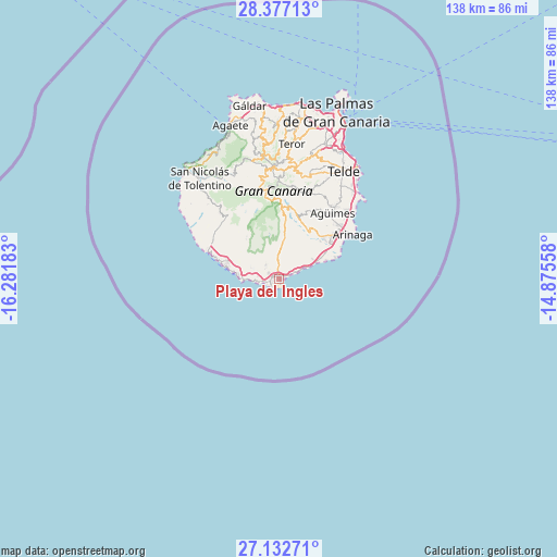
Playa del Ingles GPS coordinates[2]
27° 45' 24.12" North, 15° 34' 43.32" West
| Map corner | latitude | longitude |
|---|---|---|
| Upper-left | 28.37713°, | -16.28183° |
| Center: | 27.7567°, | -15.5787° |
| Lower-right: | 27.13271°, | -14.87558° |
| Map W x H: | 138.4×138.4 km | = 86×86mi |
| max Lat: | 43.74134° ⇑100% North |
| Playa del Ingles: | 27.7567° |
| min Lat: | ⇓0% South 27.64134° |
| min Long | Playa del Ingle | max Long |
| -18.00367° | -15.5787° | 4.2899° |
| W 1%⇐ | ⇒99% E |
Elevation
Elevation of Playa del Ingles is 49 m = 161 ft, and this is 549 m = 1801 ft below average elevation for this country.
| Max E: |
1682 m = 5518 ft | 91.3% |
| Avg. | 598 m = 1962 ft | |
| Playa del Ingles | 49 m = 161 ft | |
Min E: |
0 m = 0 ft | 8.7% |
See also: Spain elevation on elevation.city.
Geographical zone
Playa del Ingles is located in North temperate zone (between Tropic of Cancer and the Arctic Circle). Distance of this Northern Tropic circle is 480.3 km =298.4 mi to South.| Distance of | km | miles | from Playa del Ingles |
|---|---|---|---|
| North Pole | 6920.8 | 4300.4 | to North |
| Arctic Circle | 4314.9 | 2681.2 | to North |
| Tropic Cancer | 480.3 | 298.4 | to South |
| Equator | 3086.3 | 1917.7 | to South |


Nearby cities:
15 places around Playa del Ingles: (largest is in red/bold)
• Agüimes
21.1 km =13.1 mi,  38°
38°
• Artenara
30.1 km =18.7 mi,  347°
347°
• Carrizal
24.2 km =15 mi, 44°
• Cruce de Arinaga
19.9 km =12.4 mi,  48°
48°
• Ingenio
22.9 km =14.2 mi, 38°
• Maspalomas
0.8 km =0.5 mi,  300°
300°
• Mogán
20.2 km =12.6 mi,  314°
314°
• Puerto Rico
13.5 km =8.4 mi,  285°
285°
• San Bartolomé de Tirajana
18.7 km =11.6 mi,  1°
1°
• Santa Lucía
17.6 km =10.9 mi,  12°
12°
• Tejeda
26.8 km =16.7 mi, 352°
• Telde
30.5 km =19 mi,  30°
30°
• Valsequillo de Gran Canaria
26.7 km =16.6 mi,  17°
17°
• Vecindario
16.5 km =10.3 mi, 52°
• Vega de San Mateo
28.4 km =17.6 mi, 9°
Sources, notices
• [Note1] Compared only with cities in Spain existing in our database
• [Src1] Map data: © OpenStreetMap contributors (CC-BY-SA)
• [Src2] Other city data from geonames.org with taken over terms of usage.
• [Src3] Geographical zone / Annual Mean Temperature by Robert A. Rohde @ Wikipedia
