Manzanilla geodata
Manzanilla (Andalusia) is a seat of a third-order administrative division; located in Spain in Europe/Madrid (GMT+2) time zone. With population of 2,408 people, there are 1938 cities with bigger population in this country. Compared to other cities in Spain, 92% of cities are located further ↑North; 90.6% of cities are located further →East and 82.9% of cities have higher elevation than Manzanilla. Note1


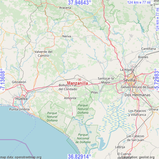
Manzanilla GPS coordinates[2]
37° 23' 23.532" North, 6° 25' 58.62" West
| Map corner | latitude | longitude |
|---|---|---|
| Upper-left | 37.94643°, | -7.13608° |
| Center: | 37.38987°, | -6.43295° |
| Lower-right: | 36.82914°, | -5.72983° |
| Map W x H: | 124.2×124.2 km | = 77.2×77.2mi |
| max Lat: | 43.74134° ⇑92% North |
| Manzanilla: | 37.38987° |
| min Lat: | ⇓8% South 27.64134° |
| min Long | Manzanilla | max Long |
| -18.00367° | -6.43295° | 4.2899° |
| W 9.4%⇐ | ⇒90.6% E |
Elevation
Elevation of Manzanilla is 169 m = 554 ft, and this is 429 m = 1407 ft below average elevation for this country.
| Max E: |
1682 m = 5518 ft | 82.9% |
| Avg. | 598 m = 1962 ft | |
| Manzanilla | 169 m = 554 ft | |
Min E: |
0 m = 0 ft | 17.1% |
See also: Spain elevation on elevation.city.
Geographical zone
Manzanilla is located in North temperate zone (between Tropic of Cancer and the Arctic Circle). Distance of this Northern Tropic circle is 1551.4 km =964 mi to South.| Distance of | km | miles | from Manzanilla |
|---|---|---|---|
| North Pole | 5849.7 | 3634.8 | to North |
| Arctic Circle | 3243.8 | 2015.6 | to North |
| Tropic Cancer | 1551.4 | 964 | to South |
| Equator | 4157.4 | 2583.3 | to South |


Nearby cities:
15 places around Manzanilla: (largest is in red/bold)
• Almonte
15.8 km =9.8 mi,  208°
208°
• Aznalcázar
18.8 km =11.7 mi,  120°
120°
• Aznalcóllar
20.3 km =12.6 mi,  45°
45°
• Bollullos par del Condado
10.9 km =6.8 mi,  240°
240°
• Carrión de los Céspedes
9.4 km =5.8 mi,  103°
103°
• Castilleja del Campo
8.7 km =5.4 mi,  92°
92°
• Chucena
4.6 km =2.9 mi,  130°
130°
• Escacena del Campo
4.4 km =2.7 mi,  62°
62°
• Hinojos
11.9 km =7.4 mi,  156°
156°
• La Palma del Condado
10.6 km =6.6 mi,  267°
267°
• Paterna del Campo
4.3 km =2.7 mi,  39°
39°
• Pilas
15.1 km =9.4 mi, 129°
• Villalba del Alcor
3.8 km =2.4 mi,  282°
282°
• Villamanrique de la Condesa
19.6 km =12.2 mi,  145°
145°
• Villarrasa
15.3 km =9.5 mi, 269°
Sources, notices
• [Note1] Compared only with cities in Spain existing in our database
• [Src1] Map data: © OpenStreetMap contributors (CC-BY-SA)
• [Src2] Other city data from geonames.org with taken over terms of usage.
• [Src3] Geographical zone / Annual Mean Temperature by Robert A. Rohde @ Wikipedia
