Hinojos geodata
Hinojos (Andalusia) is a populated place; located in Spain in Europe/Madrid (GMT+2) time zone. With population of 3,751 people, there are 1529 cities with bigger population in this country. Compared to other cities in Spain, 93.1% of cities are located further ↑North; 90.2% of cities are located further →East and 88.8% of cities have higher elevation than Hinojos. Note1


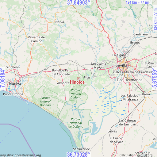
Hinojos GPS coordinates[2]
37° 17' 30.228" North, 6° 22' 43.392" West
| Map corner | latitude | longitude |
|---|---|---|
| Upper-left | 37.84903°, | -7.08184° |
| Center: | 37.29173°, | -6.37872° |
| Lower-right: | 36.73028°, | -5.67559° |
| Map W x H: | 124.4×124.4 km | = 77.3×77.3mi |
| max Lat: | 43.74134° ⇑93.1% North |
| Hinojos: | 37.29173° |
| min Lat: | ⇓6.9% South 27.64134° |
| min Long | Hinojos | max Long |
| -18.00367° | -6.37872° | 4.2899° |
| W 9.8%⇐ | ⇒90.2% E |
Elevation
Elevation of Hinojos is 84 m = 276 ft, and this is 514 m = 1686 ft below average elevation for this country.
| Max E: |
1682 m = 5518 ft | 88.8% |
| Avg. | 598 m = 1962 ft | |
| Hinojos | 84 m = 276 ft | |
Min E: |
0 m = 0 ft | 11.2% |
See also: Spain elevation on elevation.city.
Geographical zone
Hinojos is located in North temperate zone (between Tropic of Cancer and the Arctic Circle). Distance of this Northern Tropic circle is 1540.5 km =957.2 mi to South.| Distance of | km | miles | from Hinojos |
|---|---|---|---|
| North Pole | 5860.6 | 3641.6 | to North |
| Arctic Circle | 3254.7 | 2022.4 | to North |
| Tropic Cancer | 1540.5 | 957.2 | to South |
| Equator | 4146.5 | 2576.5 | to South |


Nearby cities:
15 places around Hinojos: (largest is in red/bold)
• Almonte
12.6 km =7.8 mi,  256°
256°
• Aznalcázar
11.5 km =7.1 mi,  83°
83°
• Benacazón
17.5 km =10.9 mi,  67°
67°
• Bollullos par del Condado
15.3 km =9.5 mi,  291°
291°
• Carrión de los Céspedes
9.7 km =6 mi,  26°
26°
• Castilleja del Campo
11.2 km =7 mi,  20°
20°
• Chucena
8 km =5 mi,  350°
350°
• Escacena del Campo
13 km =8.1 mi,  356°
356°
• La Palma del Condado
18.6 km =11.6 mi,  304°
304°
• Manzanilla
11.9 km =7.4 mi,  336°
336°
• Paterna del Campo
14.4 km =8.9 mi, 351°
• Pilas
7 km =4.3 mi, 79°
• Sanlúcar la Mayor
18.8 km =11.7 mi,  55°
55°
• Villalba del Alcor
14.5 km =9 mi,  324°
324°
• Villamanrique de la Condesa
8.2 km =5.1 mi,  129°
129°
Sources, notices
• [Note1] Compared only with cities in Spain existing in our database
• [Src1] Map data: © OpenStreetMap contributors (CC-BY-SA)
• [Src2] Other city data from geonames.org with taken over terms of usage.
• [Src3] Geographical zone / Annual Mean Temperature by Robert A. Rohde @ Wikipedia
