Aznalcázar geodata
Aznalcázar (Andalusia) is a populated place; located in Spain in Europe/Madrid (GMT+2) time zone. With population of 3,647 people, there are 1552 cities with bigger population in this country. Compared to other cities in Spain, 92.9% of cities are located further ↑North; 89% of cities are located further →East and 89.9% of cities have higher elevation than Aznalcázar. Note1


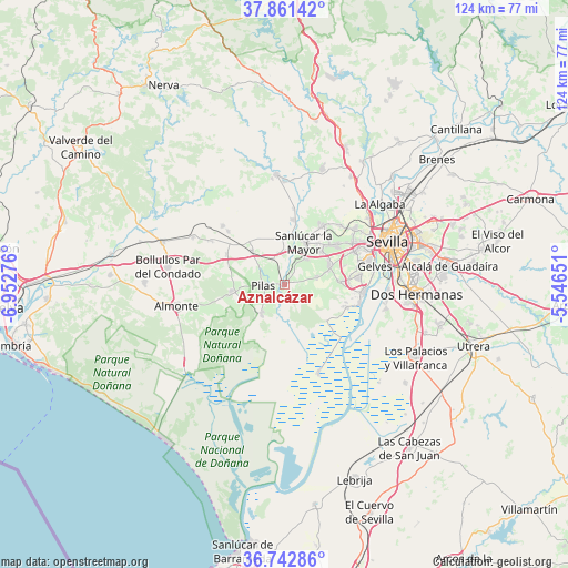
Aznalcázar GPS coordinates[2]
37° 18' 15.192" North, 6° 14' 58.668" West
| Map corner | latitude | longitude |
|---|---|---|
| Upper-left | 37.86142°, | -6.95276° |
| Center: | 37.30422°, | -6.24963° |
| Lower-right: | 36.74286°, | -5.54651° |
| Map W x H: | 124.4×124.4 km | = 77.3×77.3mi |
| max Lat: | 43.74134° ⇑92.9% North |
| Aznalcázar: | 37.30422° |
| min Lat: | ⇓7.1% South 27.64134° |
| min Long | Aznalcázar | max Long |
| -18.00367° | -6.24963° | 4.2899° |
| W 11%⇐ | ⇒89% E |
Elevation
Elevation of Aznalcázar is 67 m = 220 ft, and this is 531 m = 1742 ft below average elevation for this country.
| Max E: |
1682 m = 5518 ft | 89.9% |
| Avg. | 598 m = 1962 ft | |
| Aznalcázar | 67 m = 220 ft | |
Min E: |
0 m = 0 ft | 10.1% |
See also: Spain elevation on elevation.city.
Geographical zone
Aznalcázar is located in North temperate zone (between Tropic of Cancer and the Arctic Circle). Distance of this Northern Tropic circle is 1541.9 km =958.1 mi to South.| Distance of | km | miles | from Aznalcázar |
|---|---|---|---|
| North Pole | 5859.2 | 3640.7 | to North |
| Arctic Circle | 3253.3 | 2021.5 | to North |
| Tropic Cancer | 1541.9 | 958.1 | to South |
| Equator | 4147.8 | 2577.3 | to South |


Nearby cities:
15 places around Aznalcázar: (largest is in red/bold)
• Albaida del Aljarafe
15.2 km =9.4 mi,  28°
28°
• Almensilla
12.4 km =7.7 mi,  86°
86°
• Benacazón
7.2 km =4.5 mi,  40°
40°
• Bollullos de la Mitación
10.7 km =6.6 mi,  68°
68°
• Carrión de los Céspedes
10.2 km =6.3 mi,  316°
316°
• Castilleja del Campo
11.8 km =7.3 mi, 320°
• Chucena
14.3 km =8.9 mi,  297°
297°
• Espartinas
13.9 km =8.6 mi,  51°
51°
• Hinojos
11.5 km =7.1 mi,  263°
263°
• Olivares
15.1 km =9.4 mi, 33°
• Pilas
4.5 km =2.8 mi,  268°
268°
• Sanlúcar la Mayor
10.1 km =6.3 mi,  23°
23°
• Umbrete
10.8 km =6.7 mi, 48°
• Villamanrique de la Condesa
8.3 km =5.2 mi,  217°
217°
• Villanueva del Ariscal
14 km =8.7 mi, 43°
Sources, notices
• [Note1] Compared only with cities in Spain existing in our database
• [Src1] Map data: © OpenStreetMap contributors (CC-BY-SA)
• [Src2] Other city data from geonames.org with taken over terms of usage.
• [Src3] Geographical zone / Annual Mean Temperature by Robert A. Rohde @ Wikipedia
