Chucena geodata
Chucena (Andalusia) is a seat of a third-order administrative division; located in Spain in Europe/Madrid (GMT+2) time zone. With population of 1,988 people, there are 2179 cities with bigger population in this country. Compared to other cities in Spain, 92.3% of cities are located further ↑North; 90.3% of cities are located further →East and 84.5% of cities have higher elevation than Chucena. Note1


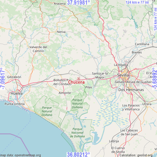
Chucena GPS coordinates[2]
37° 21' 46.98" North, 6° 23' 34.944" West
| Map corner | latitude | longitude |
|---|---|---|
| Upper-left | 37.91981°, | -7.09617° |
| Center: | 37.36305°, | -6.39304° |
| Lower-right: | 36.80212°, | -5.68992° |
| Map W x H: | 124.3×124.3 km | = 77.2×77.2mi |
| max Lat: | 43.74134° ⇑92.3% North |
| Chucena: | 37.36305° |
| min Lat: | ⇓7.7% South 27.64134° |
| min Long | Chucena | max Long |
| -18.00367° | -6.39304° | 4.2899° |
| W 9.7%⇐ | ⇒90.3% E |
Elevation
Elevation of Chucena is 147 m = 482 ft, and this is 451 m = 1480 ft below average elevation for this country.
| Max E: |
1682 m = 5518 ft | 84.5% |
| Avg. | 598 m = 1962 ft | |
| Chucena | 147 m = 482 ft | |
Min E: |
0 m = 0 ft | 15.5% |
See also: Spain elevation on elevation.city.
Geographical zone
Chucena is located in North temperate zone (between Tropic of Cancer and the Arctic Circle). Distance of this Northern Tropic circle is 1548.5 km =962.2 mi to South.| Distance of | km | miles | from Chucena |
|---|---|---|---|
| North Pole | 5852.7 | 3636.7 | to North |
| Arctic Circle | 3246.8 | 2017.5 | to North |
| Tropic Cancer | 1548.5 | 962.2 | to South |
| Equator | 4154.4 | 2581.4 | to South |


Nearby cities:
15 places around Chucena: (largest is in red/bold)
• Almonte
15.5 km =9.6 mi,  224°
224°
• Aznalcázar
14.3 km =8.9 mi,  117°
117°
• Benacazón
17.4 km =10.8 mi,  93°
93°
• Bollullos par del Condado
13.2 km =8.2 mi,  259°
259°
• Carrión de los Céspedes
5.7 km =3.5 mi,  82°
82°
• Castilleja del Campo
5.8 km =3.6 mi,  63°
63°
• Escacena del Campo
5.1 km =3.2 mi,  4°
4°
• Hinojos
8 km =5 mi,  170°
170°
• La Palma del Condado
14.3 km =8.9 mi,  280°
280°
• Manzanilla
4.6 km =2.9 mi,  310°
310°
• Paterna del Campo
6.3 km =3.9 mi,  352°
352°
• Pilas
10.5 km =6.5 mi,  129°
129°
• Sanlúcar la Mayor
17 km =10.6 mi, 80°
• Villalba del Alcor
8.2 km =5.1 mi,  297°
297°
• Villamanrique de la Condesa
15.2 km =9.4 mi,  149°
149°
Sources, notices
• [Note1] Compared only with cities in Spain existing in our database
• [Src1] Map data: © OpenStreetMap contributors (CC-BY-SA)
• [Src2] Other city data from geonames.org with taken over terms of usage.
• [Src3] Geographical zone / Annual Mean Temperature by Robert A. Rohde @ Wikipedia
