Castilleja del Campo geodata
Castilleja del Campo (Andalusia) is a seat of a third-order administrative division; located in Spain in Europe/Madrid (GMT+2) time zone. With population of 640 people, there are 3521 cities with bigger population in this country. Compared to other cities in Spain, 92.1% of cities are located further ↑North; 89.8% of cities are located further →East and 86.9% of cities have higher elevation than Castilleja del Campo. Note1
Administrative division(s):
- Level 1: Andalusia
- Level 2: Provincia de Sevilla
- Level 3: Castilleja del Campo


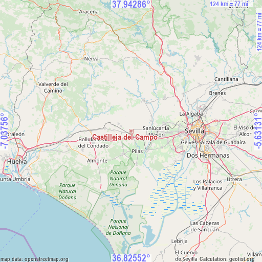
Castilleja del Campo GPS coordinates[2]
37° 23' 10.572" North, 6° 20' 3.948" West
| Map corner | latitude | longitude |
|---|---|---|
| Upper-left | 37.94286°, | -7.03756° |
| Center: | 37.38627°, | -6.33443° |
| Lower-right: | 36.82552°, | -5.63131° |
| Map W x H: | 124.2×124.2 km | = 77.2×77.2mi |
| max Lat: | 43.74134° ⇑92.1% North |
| Castilleja del Campo: | 37.38627° |
| min Lat: | ⇓7.9% South 27.64134° |
| min Long | Castilleja del | max Long |
| -18.00367° | -6.33443° | 4.2899° |
| W 10.2%⇐ | ⇒89.8% E |
Elevation
Elevation of Castilleja del Campo is 111 m = 364 ft, and this is 487 m = 1598 ft below average elevation for this country.
| Max E: |
1682 m = 5518 ft | 86.9% |
| Avg. | 598 m = 1962 ft | |
| Castilleja del Campo | 111 m = 364 ft | |
Min E: |
0 m = 0 ft | 13.1% |
See also: Spain elevation on elevation.city.
Geographical zone
Castilleja del Campo is located in North temperate zone (between Tropic of Cancer and the Arctic Circle). Distance of this Northern Tropic circle is 1551 km =963.7 mi to South.| Distance of | km | miles | from Castilleja del Campo |
|---|---|---|---|
| North Pole | 5850.1 | 3635.1 | to North |
| Arctic Circle | 3244.2 | 2015.9 | to North |
| Tropic Cancer | 1551 | 963.7 | to South |
| Equator | 4157 | 2583 | to South |


Nearby cities:
15 places around Castilleja del Campo: (largest is in red/bold)
• Albaida del Aljarafe
15.4 km =9.6 mi,  74°
74°
• Aznalcázar
11.8 km =7.3 mi,  140°
140°
• Aznalcóllar
15.8 km =9.8 mi,  21°
21°
• Benacazón
12.7 km =7.9 mi,  106°
106°
• Carrión de los Céspedes
1.9 km =1.2 mi,  165°
165°
• Chucena
5.8 km =3.6 mi,  243°
243°
• Escacena del Campo
5.4 km =3.4 mi,  297°
297°
• Hinojos
11.2 km =7 mi,  200°
200°
• Manzanilla
8.7 km =5.4 mi,  272°
272°
• Paterna del Campo
7.1 km =4.4 mi, 301°
• Pilas
9.7 km =6 mi,  162°
162°
• Sanlúcar la Mayor
11.6 km =7.2 mi,  89°
89°
• Umbrete
15.7 km =9.8 mi,  97°
97°
• Villalba del Alcor
12.4 km =7.7 mi,  275°
275°
• Villamanrique de la Condesa
15.9 km =9.9 mi, 171°
Sources, notices
• [Note1] Compared only with cities in Spain existing in our database
• [Src1] Map data: © OpenStreetMap contributors (CC-BY-SA)
• [Src2] Other city data from geonames.org with taken over terms of usage.
• [Src3] Geographical zone / Annual Mean Temperature by Robert A. Rohde @ Wikipedia
