La Palma del Condado geodata
La Palma del Condado (Andalusia) is a populated place; located in Spain in Europe/Madrid (GMT+2) time zone. With population of 10,404 people, there are 831 cities with bigger population in this country. Compared to other cities in Spain, 92.1% of cities are located further ↑North; 91.6% of cities are located further →East and 87.7% of cities have higher elevation than La Palma del Condado. Note1
Administrative division(s):
- Level 1: Andalusia
- Level 2: Provincia de Huelva
- Level 3: Palma del Condado, La


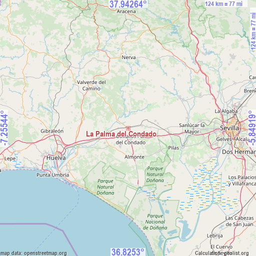
La Palma del Condado GPS coordinates[2]
37° 23' 9.78" North, 6° 33' 8.316" West
| Map corner | latitude | longitude |
|---|---|---|
| Upper-left | 37.94264°, | -7.25544° |
| Center: | 37.38605°, | -6.55231° |
| Lower-right: | 36.8253°, | -5.84919° |
| Map W x H: | 124.2×124.2 km | = 77.2×77.2mi |
| max Lat: | 43.74134° ⇑92.1% North |
| La Palma del Condado: | 37.38605° |
| min Lat: | ⇓7.9% South 27.64134° |
| min Long | La Palma del Co | max Long |
| -18.00367° | -6.55231° | 4.2899° |
| W 8.4%⇐ | ⇒91.6% E |
Elevation
Elevation of La Palma del Condado is 99 m = 325 ft, and this is 499 m = 1637 ft below average elevation for this country.
| Max E: |
1682 m = 5518 ft | 87.7% |
| Avg. | 598 m = 1962 ft | |
| La Palma del Condado | 99 m = 325 ft | |
Min E: |
0 m = 0 ft | 12.3% |
See also: Spain elevation on elevation.city.
Geographical zone
La Palma del Condado is located in North temperate zone (between Tropic of Cancer and the Arctic Circle). Distance of this Northern Tropic circle is 1551 km =963.7 mi to South.| Distance of | km | miles | from La Palma del Condado |
|---|---|---|---|
| North Pole | 5850.1 | 3635.1 | to North |
| Arctic Circle | 3244.2 | 2015.9 | to North |
| Tropic Cancer | 1551 | 963.7 | to South |
| Equator | 4156.9 | 2583 | to South |


Nearby cities:
15 places around La Palma del Condado: (largest is in red/bold)
• Almonte
13.9 km =8.6 mi,  166°
166°
• Beas
21.7 km =13.5 mi,  281°
281°
• Bollullos par del Condado
5.1 km =3.2 mi, 167°
• Bonares
13.3 km =8.3 mi,  238°
238°
• Carrión de los Céspedes
19.8 km =12.3 mi,  95°
95°
• Castilleja del Campo
19.2 km =11.9 mi,  89°
89°
• Chucena
14.3 km =8.9 mi, 100°
• Escacena del Campo
14.7 km =9.1 mi,  80°
80°
• Hinojos
18.6 km =11.6 mi,  124°
124°
• Lucena del Puerto
18.1 km =11.2 mi, 239°
• Manzanilla
10.6 km =6.6 mi, 87°
• Niebla
11.5 km =7.1 mi,  256°
256°
• Paterna del Campo
13.7 km =8.5 mi,  74°
74°
• Villalba del Alcor
7 km =4.3 mi, 79°
• Villarrasa
4.8 km =3 mi,  273°
273°
Sources, notices
• [Note1] Compared only with cities in Spain existing in our database
• [Src1] Map data: © OpenStreetMap contributors (CC-BY-SA)
• [Src2] Other city data from geonames.org with taken over terms of usage.
• [Src3] Geographical zone / Annual Mean Temperature by Robert A. Rohde @ Wikipedia
