Magacela geodata
Magacela (Extremadura) is a seat of a third-order administrative division; located in Spain in Europe/Madrid (GMT+2) time zone. With population of 670 people, there are 3465 cities with bigger population in this country. Compared to other cities in Spain, 82.2% of cities are located further ↑North; 82.2% of cities are located further →East and 65.3% of cities have higher elevation than Magacela. Note1


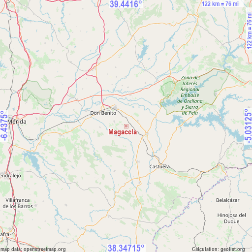
Magacela GPS coordinates[2]
38° 53' 47.328" North, 5° 44' 3.732" West
| Map corner | latitude | longitude |
|---|---|---|
| Upper-left | 39.4416°, | -6.4375° |
| Center: | 38.89648°, | -5.73437° |
| Lower-right: | 38.34715°, | -5.03125° |
| Map W x H: | 121.7×121.7 km | = 75.6×75.6mi |
| max Lat: | 43.74134° ⇑82.2% North |
| Magacela: | 38.89648° |
| min Lat: | ⇓17.8% South 27.64134° |
| min Long | Magacela | max Long |
| -18.00367° | -5.73437° | 4.2899° |
| W 17.8%⇐ | ⇒82.2% E |
Elevation
Elevation of Magacela is 456 m = 1496 ft, and this is 142 m = 466 ft below average elevation for this country.
| Max E: |
1682 m = 5518 ft | 65.3% |
| Avg. | 598 m = 1962 ft | |
| Magacela | 456 m = 1496 ft | |
Min E: |
0 m = 0 ft | 34.7% |
See also: Spain elevation on elevation.city.
Geographical zone
Magacela is located in North temperate zone (between Tropic of Cancer and the Arctic Circle). Distance of this Northern Tropic circle is 1719 km =1068.1 mi to South.| Distance of | km | miles | from Magacela |
|---|---|---|---|
| North Pole | 5682.2 | 3530.8 | to North |
| Arctic Circle | 3076.3 | 1911.5 | to North |
| Tropic Cancer | 1719 | 1068.1 | to South |
| Equator | 4324.9 | 2687.4 | to South |


Nearby cities:
15 places around Magacela: (largest is in red/bold)
• Acedera
24.4 km =15.2 mi,  34°
34°
• Campanario
10.7 km =6.6 mi,  109°
109°
• Castuera
24.6 km =15.3 mi,  137°
137°
• Don Benito
12.9 km =8 mi,  301°
301°
• La Coronada
6.2 km =3.9 mi,  64°
64°
• La Haba
6.2 km =3.9 mi,  293°
293°
• Malpartida de la Serena
26 km =16.2 mi,  161°
161°
• Medellín
20.7 km =12.9 mi, 290°
• Mengabril
17.8 km =11.1 mi,  284°
284°
• Orellana la Vieja
21.2 km =13.2 mi,  54°
54°
• Quintana de la Serena
17.6 km =10.9 mi, 162°
• Rena
18.5 km =11.5 mi,  339°
339°
• Valle de la Serena
21.5 km =13.4 mi,  195°
195°
• Villanueva de la Serena
10.4 km =6.5 mi,  328°
328°
• Villar de Rena
21.1 km =13.1 mi, 341°
Sources, notices
• [Note1] Compared only with cities in Spain existing in our database
• [Src1] Map data: © OpenStreetMap contributors (CC-BY-SA)
• [Src2] Other city data from geonames.org with taken over terms of usage.
• [Src3] Geographical zone / Annual Mean Temperature by Robert A. Rohde @ Wikipedia
