Rena geodata
Rena (Extremadura) is a seat of a third-order administrative division; located in Spain in Europe/Madrid (GMT+2) time zone. With population of 646 people, there are 3508 cities with bigger population in this country. Compared to other cities in Spain, 80.5% of cities are located further ↑North; 83.4% of cities are located further →East and 77.9% of cities have higher elevation than Rena. Note1


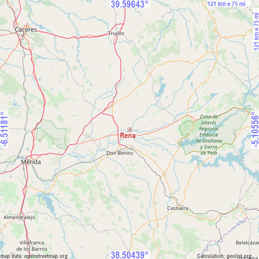
Rena GPS coordinates[2]
39° 3' 9.072" North, 5° 48' 31.248" West
| Map corner | latitude | longitude |
|---|---|---|
| Upper-left | 39.59643°, | -6.51181° |
| Center: | 39.05252°, | -5.80868° |
| Lower-right: | 38.50439°, | -5.10556° |
| Map W x H: | 121.4×121.4 km | = 75.4×75.4mi |
| max Lat: | 43.74134° ⇑80.5% North |
| Rena: | 39.05252° |
| min Lat: | ⇓19.5% South 27.64134° |
| min Long | Rena | max Long |
| -18.00367° | -5.80868° | 4.2899° |
| W 16.6%⇐ | ⇒83.4% E |
Elevation
Elevation of Rena is 258 m = 846 ft, and this is 340 m = 1115 ft below average elevation for this country.
| Max E: |
1682 m = 5518 ft | 77.9% |
| Avg. | 598 m = 1962 ft | |
| Rena | 258 m = 846 ft | |
Min E: |
0 m = 0 ft | 22.1% |
See also: Spain elevation on elevation.city.
Geographical zone
Rena is located in North temperate zone (between Tropic of Cancer and the Arctic Circle). Distance of this Northern Tropic circle is 1736.3 km =1078.9 mi to South.| Distance of | km | miles | from Rena |
|---|---|---|---|
| North Pole | 5664.8 | 3519.9 | to North |
| Arctic Circle | 3058.9 | 1900.7 | to North |
| Tropic Cancer | 1736.3 | 1078.9 | to South |
| Equator | 4342.2 | 2698.1 | to South |


Nearby cities:
15 places around Rena: (largest is in red/bold)
• Abertura
21.2 km =13.2 mi,  358°
358°
• Acedera
20.5 km =12.7 mi,  82°
82°
• Alcollarín
22.2 km =13.8 mi,  15°
15°
• Don Benito
11.6 km =7.2 mi,  203°
203°
• Escurial
14.5 km =9 mi,  333°
333°
• La Coronada
19 km =11.8 mi,  140°
140°
• La Haba
14.8 km =9.2 mi,  177°
177°
• Madrigalejo
18.3 km =11.4 mi,  58°
58°
• Magacela
18.5 km =11.5 mi,  159°
159°
• Medellín
16.3 km =10.1 mi,  232°
232°
• Mengabril
16.9 km =10.5 mi,  219°
219°
• Miajadas
14 km =8.7 mi,  321°
321°
• Santa Amalia
18.1 km =11.2 mi,  255°
255°
• Villanueva de la Serena
8.5 km =5.3 mi,  173°
173°
• Villar de Rena
2.7 km =1.7 mi, 356°
Sources, notices
• [Note1] Compared only with cities in Spain existing in our database
• [Src1] Map data: © OpenStreetMap contributors (CC-BY-SA)
• [Src2] Other city data from geonames.org with taken over terms of usage.
• [Src3] Geographical zone / Annual Mean Temperature by Robert A. Rohde @ Wikipedia
