La Haba geodata
La Haba (Extremadura) is a populated place; located in Spain in Europe/Madrid (GMT+2) time zone. With population of 1,450 people, there are 2513 cities with bigger population in this country. Compared to other cities in Spain, 81.9% of cities are located further ↑North; 83.2% of cities are located further →East and 74.1% of cities have higher elevation than La Haba. Note1


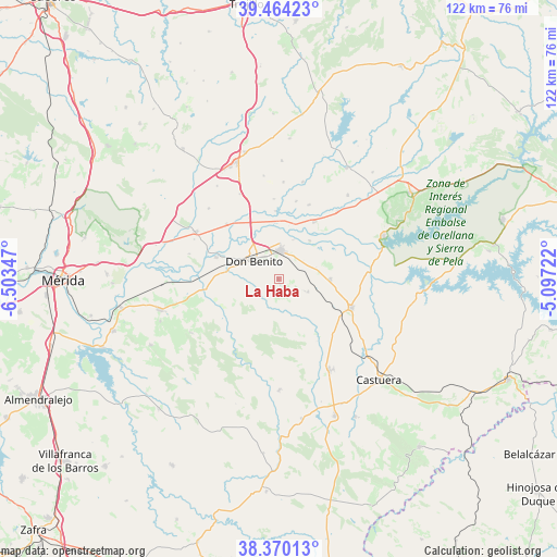
La Haba GPS coordinates[2]
38° 55' 9.444" North, 5° 48' 1.224" West
| Map corner | latitude | longitude |
|---|---|---|
| Upper-left | 39.46423°, | -6.50347° |
| Center: | 38.91929°, | -5.80034° |
| Lower-right: | 38.37013°, | -5.09722° |
| Map W x H: | 121.7×121.7 km | = 75.6×75.6mi |
| max Lat: | 43.74134° ⇑81.9% North |
| La Haba: | 38.91929° |
| min Lat: | ⇓18.1% South 27.64134° |
| min Long | La Haba | max Long |
| -18.00367° | -5.80034° | 4.2899° |
| W 16.8%⇐ | ⇒83.2% E |
Elevation
Elevation of La Haba is 313 m = 1027 ft, and this is 285 m = 935 ft below average elevation for this country.
| Max E: |
1682 m = 5518 ft | 74.1% |
| Avg. | 598 m = 1962 ft | |
| La Haba | 313 m = 1027 ft | |
Min E: |
0 m = 0 ft | 25.9% |
See also: Spain elevation on elevation.city.
Geographical zone
La Haba is located in North temperate zone (between Tropic of Cancer and the Arctic Circle). Distance of this Northern Tropic circle is 1721.5 km =1069.7 mi to South.| Distance of | km | miles | from La Haba |
|---|---|---|---|
| North Pole | 5679.6 | 3529.1 | to North |
| Arctic Circle | 3073.8 | 1910 | to North |
| Tropic Cancer | 1721.5 | 1069.7 | to South |
| Equator | 4327.4 | 2688.9 | to South |


Nearby cities:
15 places around La Haba: (largest is in red/bold)
• Campanario
17 km =10.6 mi,  111°
111°
• Don Benito
6.7 km =4.2 mi,  307°
307°
• La Coronada
11.3 km =7 mi,  89°
89°
• Magacela
6.2 km =3.9 mi, 113°
• Manchita
22.4 km =13.9 mi,  238°
238°
• Medellín
14.4 km =8.9 mi,  289°
289°
• Mengabril
11.6 km =7.2 mi,  278°
278°
• Orellana la Vieja
24.9 km =15.5 mi,  67°
67°
• Quintana de la Serena
22.2 km =13.8 mi,  150°
150°
• Rena
14.8 km =9.2 mi,  357°
357°
• Santa Amalia
20.9 km =13 mi,  299°
299°
• Valdetorres
23.1 km =14.4 mi,  268°
268°
• Valle de la Serena
23.3 km =14.5 mi,  179°
179°
• Villanueva de la Serena
6.4 km =4 mi,  2°
2°
• Villar de Rena
17.5 km =10.9 mi, 357°
Sources, notices
• [Note1] Compared only with cities in Spain existing in our database
• [Src1] Map data: © OpenStreetMap contributors (CC-BY-SA)
• [Src2] Other city data from geonames.org with taken over terms of usage.
• [Src3] Geographical zone / Annual Mean Temperature by Robert A. Rohde @ Wikipedia
