Mengabril geodata
Mengabril (Extremadura) is a seat of a third-order administrative division; located in Spain in Europe/Madrid (GMT+2) time zone. With population of 457 people, there are 3992 cities with bigger population in this country. Compared to other cities in Spain, 81.7% of cities are located further ↑North; 85.2% of cities are located further →East and 78.1% of cities have higher elevation than Mengabril. Note1


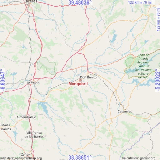
Mengabril GPS coordinates[2]
38° 56' 7.944" North, 5° 56' 0.06" West
| Map corner | latitude | longitude |
|---|---|---|
| Upper-left | 39.48036°, | -6.63647° |
| Center: | 38.93554°, | -5.93335° |
| Lower-right: | 38.38651°, | -5.23022° |
| Map W x H: | 121.6×121.6 km | = 75.6×75.6mi |
| max Lat: | 43.74134° ⇑81.7% North |
| Mengabril: | 38.93554° |
| min Lat: | ⇓18.3% South 27.64134° |
| min Long | Mengabril | max Long |
| -18.00367° | -5.93335° | 4.2899° |
| W 14.8%⇐ | ⇒85.2% E |
Elevation
Elevation of Mengabril is 253 m = 830 ft, and this is 345 m = 1132 ft below average elevation for this country.
| Max E: |
1682 m = 5518 ft | 78.1% |
| Avg. | 598 m = 1962 ft | |
| Mengabril | 253 m = 830 ft | |
Min E: |
0 m = 0 ft | 21.9% |
See also: Spain elevation on elevation.city.
Geographical zone
Mengabril is located in North temperate zone (between Tropic of Cancer and the Arctic Circle). Distance of this Northern Tropic circle is 1723.3 km =1070.8 mi to South.| Distance of | km | miles | from Mengabril |
|---|---|---|---|
| North Pole | 5677.8 | 3528 | to North |
| Arctic Circle | 3071.9 | 1908.8 | to North |
| Tropic Cancer | 1723.3 | 1070.8 | to South |
| Equator | 4329.2 | 2690 | to South |


Nearby cities:
15 places around Mengabril: (largest is in red/bold)
• Cristina
18 km =11.2 mi,  232°
232°
• Don Benito
6.6 km =4.1 mi,  69°
69°
• Guareña
16.7 km =10.4 mi,  239°
239°
• La Coronada
22.9 km =14.2 mi,  94°
94°
• La Haba
11.6 km =7.2 mi,  98°
98°
• Magacela
17.8 km =11.1 mi, 104°
• Manchita
15.5 km =9.6 mi,  209°
209°
• Medellín
3.7 km =2.3 mi,  324°
324°
• Oliva de Mérida
23.1 km =14.4 mi, 225°
• Rena
16.9 km =10.5 mi,  39°
39°
• San Pedro de Mérida
21.9 km =13.6 mi,  274°
274°
• Santa Amalia
10.8 km =6.7 mi, 321°
• Valdetorres
11.8 km =7.3 mi,  259°
259°
• Villanueva de la Serena
12.6 km =7.8 mi, 68°
• Villar de Rena
18.9 km =11.7 mi,  34°
34°
Sources, notices
• [Note1] Compared only with cities in Spain existing in our database
• [Src1] Map data: © OpenStreetMap contributors (CC-BY-SA)
• [Src2] Other city data from geonames.org with taken over terms of usage.
• [Src3] Geographical zone / Annual Mean Temperature by Robert A. Rohde @ Wikipedia
