Guadalupe geodata
Guadalupe (Extremadura) is a seat of a third-order administrative division; located in Spain in Europe/Madrid (GMT+2) time zone. With population of 2,252 people, there are 2027 cities with bigger population in this country. Compared to other cities in Spain, 77.3% of cities are located further ↑North; 76.6% of cities are located further →East and 51.8% of cities have higher elevation than Guadalupe. Note1


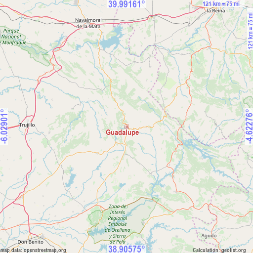
Guadalupe GPS coordinates[2]
39° 27' 2.88" North, 5° 19' 33.168" West
| Map corner | latitude | longitude |
|---|---|---|
| Upper-left | 39.99161°, | -6.02901° |
| Center: | 39.4508°, | -5.32588° |
| Lower-right: | 38.90575°, | -4.62276° |
| Map W x H: | 120.7×120.7 km | = 75×75mi |
| max Lat: | 43.74134° ⇑77.3% North |
| Guadalupe: | 39.4508° |
| min Lat: | ⇓22.7% South 27.64134° |
| min Long | Guadalupe | max Long |
| -18.00367° | -5.32588° | 4.2899° |
| W 23.4%⇐ | ⇒76.6% E |
Elevation
Elevation of Guadalupe is 640 m = 2100 ft, and this is 42 m = 138 ft above average elevation for this country.
| Max E: |
1682 m = 5518 ft | 51.8% |
| Guadalupe | 640 m 2100 ft | |
| Avg. | 598 m = 1962 ft | |
Min E: |
0 m = 0 ft | 48.2% |
See also: Spain elevation on elevation.city.
Geographical zone
Guadalupe is located in North temperate zone (between Tropic of Cancer and the Arctic Circle). Distance of this Northern Tropic circle is 1780.6 km =1106.4 mi to South.| Distance of | km | miles | from Guadalupe |
|---|---|---|---|
| North Pole | 5620.5 | 3492.4 | to North |
| Arctic Circle | 3014.7 | 1873.2 | to North |
| Tropic Cancer | 1780.6 | 1106.4 | to South |
| Equator | 4386.5 | 2725.6 | to South |


Nearby cities:
15 places around Guadalupe: (largest is in red/bold)
• Alía
9.3 km =5.8 mi,  91°
91°
• Berzocana
11.7 km =7.3 mi,  262°
262°
• Cabañas del Castillo
19.3 km =12 mi,  304°
304°
• Carrascalejo
22.4 km =13.9 mi,  24°
24°
• Castañar de Ibor
21.2 km =13.2 mi,  338°
338°
• Castilblanco
27.4 km =17 mi,  132°
132°
• Cañamero
9.5 km =5.9 mi,  214°
214°
• Garcíaz
26.3 km =16.3 mi, 260°
• Logrosán
19.2 km =11.9 mi,  228°
228°
• Mohedas de la Jara
23.2 km =14.4 mi,  42°
42°
• Navalvillar de Ibor
16.6 km =10.3 mi,  333°
333°
• Navezuelas
11.6 km =7.2 mi, 304°
• Puerto de San Vicente
19.9 km =12.4 mi,  66°
66°
• Robledollano
23.6 km =14.7 mi,  318°
318°
• Valdecaballeros
25.9 km =16.1 mi,  153°
153°
Sources, notices
• [Note1] Compared only with cities in Spain existing in our database
• [Src1] Map data: © OpenStreetMap contributors (CC-BY-SA)
• [Src2] Other city data from geonames.org with taken over terms of usage.
• [Src3] Geographical zone / Annual Mean Temperature by Robert A. Rohde @ Wikipedia
