Lobón geodata
Lobón (Extremadura) is a seat of a third-order administrative division; located in Spain in Europe/Madrid (GMT+2) time zone. With population of 2,611 people, there are 1859 cities with bigger population in this country. Compared to other cities in Spain, 82.7% of cities are located further ↑North; 92.1% of cities are located further →East and 78.8% of cities have higher elevation than Lobón. Note1


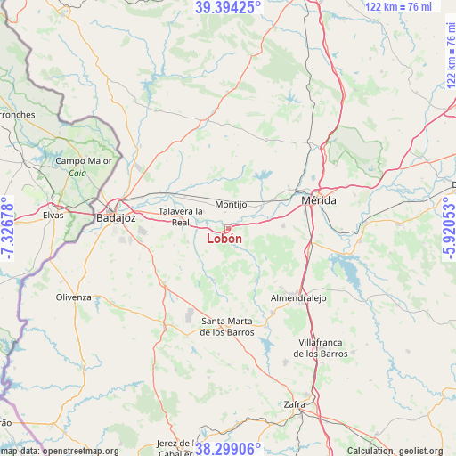
Lobón GPS coordinates[2]
38° 50' 55.536" North, 6° 37' 25.14" West
| Map corner | latitude | longitude |
|---|---|---|
| Upper-left | 39.39425°, | -7.32678° |
| Center: | 38.84876°, | -6.62365° |
| Lower-right: | 38.29906°, | -5.92053° |
| Map W x H: | 121.8×121.8 km | = 75.7×75.7mi |
| max Lat: | 43.74134° ⇑82.7% North |
| Lobón: | 38.84876° |
| min Lat: | ⇓17.3% South 27.64134° |
| min Long | Lobón | max Long |
| -18.00367° | -6.62365° | 4.2899° |
| W 7.9%⇐ | ⇒92.1% E |
Elevation
Elevation of Lobón is 241 m = 791 ft, and this is 357 m = 1171 ft below average elevation for this country.
| Max E: |
1682 m = 5518 ft | 78.8% |
| Avg. | 598 m = 1962 ft | |
| Lobón | 241 m = 791 ft | |
Min E: |
0 m = 0 ft | 21.2% |
See also: Spain elevation on elevation.city.
Geographical zone
Lobón is located in North temperate zone (between Tropic of Cancer and the Arctic Circle). Distance of this Northern Tropic circle is 1713.7 km =1064.8 mi to South.| Distance of | km | miles | from Lobón |
|---|---|---|---|
| North Pole | 5687.5 | 3534 | to North |
| Arctic Circle | 3081.6 | 1914.8 | to North |
| Tropic Cancer | 1713.7 | 1064.8 | to South |
| Equator | 4319.6 | 2684.1 | to South |


Nearby cities:
15 places around Lobón: (largest is in red/bold)
• Arroyo de San Serván
14.7 km =9.1 mi,  87°
87°
• Calamonte
20.9 km =13 mi,  77°
77°
• Corte de Peleas
14.2 km =8.8 mi,  196°
196°
• Entrín Bajo
16.4 km =10.2 mi,  208°
208°
• Esparragalejo
19.4 km =12.1 mi,  57°
57°
• La Albuera
22.6 km =14 mi,  229°
229°
• La Garrovilla
14.9 km =9.3 mi, 58°
• Montijo
6.6 km =4.1 mi,  4°
4°
• Mérida
25.4 km =15.8 mi,  72°
72°
• Puebla de la Calzada
5.1 km =3.2 mi,  357°
357°
• Solana de los Barros
15.6 km =9.7 mi,  151°
151°
• Talavera La Real
13 km =8.1 mi,  284°
284°
• Torremayor
9.4 km =5.8 mi,  51°
51°
• Torremegía
22.4 km =13.9 mi,  106°
106°
• Valdelacalzada
8 km =5 mi,  304°
304°
Sources, notices
• [Note1] Compared only with cities in Spain existing in our database
• [Src1] Map data: © OpenStreetMap contributors (CC-BY-SA)
• [Src2] Other city data from geonames.org with taken over terms of usage.
• [Src3] Geographical zone / Annual Mean Temperature by Robert A. Rohde @ Wikipedia
