Torremegía geodata
Torremegía (Extremadura) is a populated place; located in Spain in Europe/Madrid (GMT+2) time zone. With population of 2,184 people, there are 2059 cities with bigger population in this country. Compared to other cities in Spain, 83.3% of cities are located further ↑North; 90.1% of cities are located further →East and 74.5% of cities have higher elevation than Torremegía. Note1


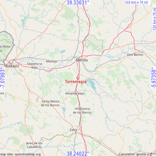
Torremegía GPS coordinates[2]
38° 47' 25.332" North, 6° 22' 36.12" West
| Map corner | latitude | longitude |
|---|---|---|
| Upper-left | 39.33631°, | -7.07983° |
| Center: | 38.79037°, | -6.3767° |
| Lower-right: | 38.24022°, | -5.67358° |
| Map W x H: | 121.9×121.9 km | = 75.7×75.7mi |
| max Lat: | 43.74134° ⇑83.3% North |
| Torremegía: | 38.79037° |
| min Lat: | ⇓16.7% South 27.64134° |
| min Long | Torremegía | max Long |
| -18.00367° | -6.3767° | 4.2899° |
| W 9.9%⇐ | ⇒90.1% E |
Elevation
Elevation of Torremegía is 305 m = 1001 ft, and this is 293 m = 961 ft below average elevation for this country.
| Max E: |
1682 m = 5518 ft | 74.5% |
| Avg. | 598 m = 1962 ft | |
| Torremegía | 305 m = 1001 ft | |
Min E: |
0 m = 0 ft | 25.5% |
See also: Spain elevation on elevation.city.
Geographical zone
Torremegía is located in North temperate zone (between Tropic of Cancer and the Arctic Circle). Distance of this Northern Tropic circle is 1707.2 km =1060.8 mi to South.| Distance of | km | miles | from Torremegía |
|---|---|---|---|
| North Pole | 5694 | 3538.1 | to North |
| Arctic Circle | 3088.1 | 1918.9 | to North |
| Tropic Cancer | 1707.2 | 1060.8 | to South |
| Equator | 4313.1 | 2680 | to South |


Nearby cities:
15 places around Torremegía: (largest is in red/bold)
• Aceuchal
18.6 km =11.6 mi,  210°
210°
• Alange
11.4 km =7.1 mi,  93°
93°
• Almendralejo
12.2 km =7.6 mi,  192°
192°
• Arroyo de San Serván
9.8 km =6.1 mi,  316°
316°
• Calamonte
11 km =6.8 mi,  354°
354°
• Don Álvaro
10.9 km =6.8 mi,  53°
53°
• Esparragalejo
17.7 km =11 mi,  343°
343°
• La Garrovilla
16.8 km =10.4 mi,  328°
328°
• Mérida
14.3 km =8.9 mi,  11°
11°
• Solana de los Barros
15.8 km =9.8 mi,  242°
242°
• Torremayor
18.7 km =11.6 mi,  311°
311°
• Trujillanos
20.8 km =12.9 mi,  29°
29°
• Valverde de Mérida
19.1 km =11.9 mi, 45°
• Villagonzalo
17.6 km =10.9 mi,  62°
62°
• Zarza de Alange
14.1 km =8.8 mi,  77°
77°
Sources, notices
• [Note1] Compared only with cities in Spain existing in our database
• [Src1] Map data: © OpenStreetMap contributors (CC-BY-SA)
• [Src2] Other city data from geonames.org with taken over terms of usage.
• [Src3] Geographical zone / Annual Mean Temperature by Robert A. Rohde @ Wikipedia
