La Garrovilla geodata
La Garrovilla (Extremadura) is a populated place; located in Spain in Europe/Madrid (GMT+2) time zone. With population of 2,528 people, there are 1894 cities with bigger population in this country. Compared to other cities in Spain, 81.9% of cities are located further ↑North; 91% of cities are located further →East and 81% of cities have higher elevation than La Garrovilla. Note1
Administrative division(s):
- Level 1: Extremadura
- Level 2: Provincia de Badajoz
- Level 3: Garrovilla, La


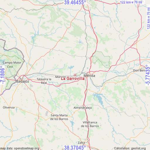
La Garrovilla GPS coordinates[2]
38° 55' 10.596" North, 6° 28' 38.892" West
| Map corner | latitude | longitude |
|---|---|---|
| Upper-left | 39.46455°, | -7.1806° |
| Center: | 38.91961°, | -6.47747° |
| Lower-right: | 38.37045°, | -5.77435° |
| Map W x H: | 121.7×121.7 km | = 75.6×75.6mi |
| max Lat: | 43.74134° ⇑81.9% North |
| La Garrovilla: | 38.91961° |
| min Lat: | ⇓18.1% South 27.64134° |
| min Long | La Garrovilla | max Long |
| -18.00367° | -6.47747° | 4.2899° |
| W 9%⇐ | ⇒91% E |
Elevation
Elevation of La Garrovilla is 204 m = 669 ft, and this is 394 m = 1293 ft below average elevation for this country.
| Max E: |
1682 m = 5518 ft | 81% |
| Avg. | 598 m = 1962 ft | |
| La Garrovilla | 204 m = 669 ft | |
Min E: |
0 m = 0 ft | 19% |
See also: Spain elevation on elevation.city.
Geographical zone
La Garrovilla is located in North temperate zone (between Tropic of Cancer and the Arctic Circle). Distance of this Northern Tropic circle is 1721.5 km =1069.7 mi to South.| Distance of | km | miles | from La Garrovilla |
|---|---|---|---|
| North Pole | 5679.6 | 3529.1 | to North |
| Arctic Circle | 3073.7 | 1909.9 | to North |
| Tropic Cancer | 1721.5 | 1069.7 | to South |
| Equator | 4327.5 | 2689 | to South |


Nearby cities:
15 places around La Garrovilla: (largest is in red/bold)
• Aljucén
18.8 km =11.7 mi,  42°
42°
• Arroyo de San Serván
7.5 km =4.7 mi,  164°
164°
• Calamonte
8.5 km =5.3 mi,  113°
113°
• Don Álvaro
19.3 km =12 mi, 114°
• Esparragalejo
4.5 km =2.8 mi,  54°
54°
• La Nava de Santiago
16.2 km =10.1 mi,  351°
351°
• Lobón
14.9 km =9.3 mi,  238°
238°
• Mirandilla
18.7 km =11.6 mi,  60°
60°
• Montijo
12.2 km =7.6 mi,  264°
264°
• Mérida
11.6 km =7.2 mi,  91°
91°
• Puebla de la Calzada
13.1 km =8.1 mi, 257°
• Torremayor
5.7 km =3.5 mi,  249°
249°
• Torremegía
16.8 km =10.4 mi,  148°
148°
• Trujillanos
19.4 km =12.1 mi,  79°
79°
• Valdelacalzada
19.6 km =12.2 mi, 260°
Sources, notices
• [Note1] Compared only with cities in Spain existing in our database
• [Src1] Map data: © OpenStreetMap contributors (CC-BY-SA)
• [Src2] Other city data from geonames.org with taken over terms of usage.
• [Src3] Geographical zone / Annual Mean Temperature by Robert A. Rohde @ Wikipedia
