Esparragalejo geodata
Esparragalejo (Extremadura) is a seat of a third-order administrative division; located in Spain in Europe/Madrid (GMT+2) time zone. With population of 1,524 people, there are 2448 cities with bigger population in this country. Compared to other cities in Spain, 81.6% of cities are located further ↑North; 90.7% of cities are located further →East and 79.2% of cities have higher elevation than Esparragalejo. Note1
Administrative division(s):
- Level 1: Extremadura
- Level 2: Provincia de Badajoz
- Level 3: Esparragalejo


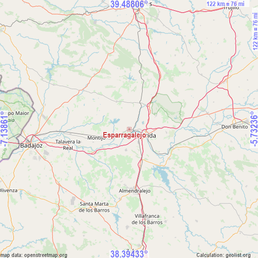
Esparragalejo GPS coordinates[2]
38° 56' 35.88" North, 6° 26' 7.764" West
| Map corner | latitude | longitude |
|---|---|---|
| Upper-left | 39.48806°, | -7.13861° |
| Center: | 38.9433°, | -6.43549° |
| Lower-right: | 38.39433°, | -5.73236° |
| Map W x H: | 121.6×121.6 km | = 75.6×75.6mi |
| max Lat: | 43.74134° ⇑81.6% North |
| Esparragalejo: | 38.9433° |
| min Lat: | ⇓18.4% South 27.64134° |
| min Long | Esparragalejo | max Long |
| -18.00367° | -6.43549° | 4.2899° |
| W 9.3%⇐ | ⇒90.7% E |
Elevation
Elevation of Esparragalejo is 235 m = 771 ft, and this is 363 m = 1191 ft below average elevation for this country.
| Max E: |
1682 m = 5518 ft | 79.2% |
| Avg. | 598 m = 1962 ft | |
| Esparragalejo | 235 m = 771 ft | |
Min E: |
0 m = 0 ft | 20.8% |
See also: Spain elevation on elevation.city.
Geographical zone
Esparragalejo is located in North temperate zone (between Tropic of Cancer and the Arctic Circle). Distance of this Northern Tropic circle is 1724.2 km =1071.4 mi to South.| Distance of | km | miles | from Esparragalejo |
|---|---|---|---|
| North Pole | 5677 | 3527.5 | to North |
| Arctic Circle | 3071.1 | 1908.3 | to North |
| Tropic Cancer | 1724.2 | 1071.4 | to South |
| Equator | 4330.1 | 2690.6 | to South |


Nearby cities:
15 places around Esparragalejo: (largest is in red/bold)
• Aljucén
14.4 km =8.9 mi,  38°
38°
• Arroyo de San Serván
10 km =6.2 mi,  189°
189°
• Calamonte
7.3 km =4.5 mi,  145°
145°
• Don Álvaro
17.5 km =10.9 mi,  127°
127°
• La Garrovilla
4.5 km =2.8 mi,  234°
234°
• La Nava de Santiago
14.6 km =9.1 mi,  335°
335°
• Lobón
19.4 km =12.1 mi,  237°
237°
• Mirandilla
14.3 km =8.9 mi,  62°
62°
• Montijo
16.2 km =10.1 mi,  256°
256°
• Mérida
8.5 km =5.3 mi,  110°
110°
• Puebla de la Calzada
17.3 km =10.7 mi,  251°
251°
• Torremayor
10.1 km =6.3 mi, 242°
• Torremegía
17.7 km =11 mi,  163°
163°
• Trujillanos
15.4 km =9.6 mi,  86°
86°
• Valverde de Mérida
19 km =11.8 mi,  100°
100°
Sources, notices
• [Note1] Compared only with cities in Spain existing in our database
• [Src1] Map data: © OpenStreetMap contributors (CC-BY-SA)
• [Src2] Other city data from geonames.org with taken over terms of usage.
• [Src3] Geographical zone / Annual Mean Temperature by Robert A. Rohde @ Wikipedia
