Chercos geodata
Chercos (Andalusia) is a seat of a third-order administrative division; located in Spain in Europe/Madrid (GMT+2) time zone. With population of 285 people, there are 4564 cities with bigger population in this country. Compared to other cities in Spain, 93.4% of cities are located further ↑North; 64% of cities are located further ←West and 81.8% of cities have lower elevation than Chercos. Note1


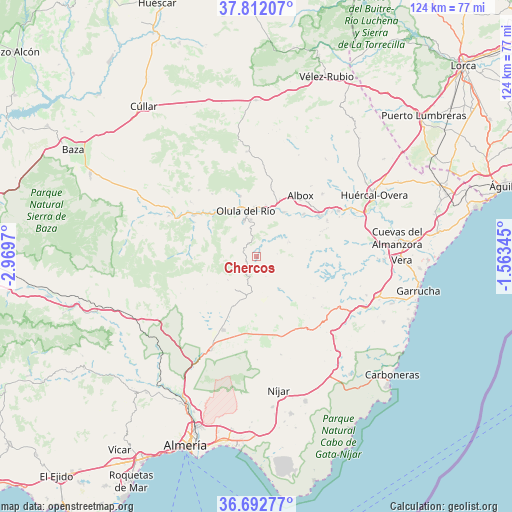
Chercos GPS coordinates[2]
37° 15' 16.2" North, 2° 15' 59.652" West
| Map corner | latitude | longitude |
|---|---|---|
| Upper-left | 37.81207°, | -2.9697° |
| Center: | 37.2545°, | -2.26657° |
| Lower-right: | 36.69277°, | -1.56345° |
| Map W x H: | 124.5×124.5 km | = 77.4×77.4mi |
| max Lat: | 43.74134° ⇑93.4% North |
| Chercos: | 37.2545° |
| min Lat: | ⇓6.6% South 27.64134° |
| min Long | Chercos | max Long |
| -18.00367° | -2.26657° | 4.2899° |
| W 64%⇐ | ⇒36% E |
Elevation
Elevation of Chercos is 915 m = 3002 ft, and this is 317 m = 1040 ft above average elevation for this country.
| Max E: |
1682 m = 5518 ft | 18.2% |
| Chercos | 915 m 3002 ft | |
| Avg. | 598 m = 1962 ft | |
Min E: |
0 m = 0 ft | 81.8% |
See also: Spain elevation on elevation.city.
Geographical zone
Chercos is located in North temperate zone (between Tropic of Cancer and the Arctic Circle). Distance of this Northern Tropic circle is 1536.4 km =954.7 mi to South.| Distance of | km | miles | from Chercos |
|---|---|---|---|
| North Pole | 5864.7 | 3644.2 | to North |
| Arctic Circle | 3258.9 | 2025 | to North |
| Tropic Cancer | 1536.4 | 954.7 | to South |
| Equator | 4142.3 | 2573.9 | to South |


Nearby cities:
15 places around Chercos: (largest is in red/bold)
• Albánchez
8.1 km =5 mi,  66°
66°
• Alcudia de Monteagud
2.1 km =1.3 mi,  179°
179°
• Benitagla
3.5 km =2.2 mi,  136°
136°
• Benizalón
5.2 km =3.2 mi,  155°
155°
• Cantoria
12.6 km =7.8 mi,  31°
31°
• Cóbdar
5 km =3.1 mi,  80°
80°
• Fines
11.8 km =7.3 mi,  3°
3°
• Laroya
7.7 km =4.8 mi,  308°
308°
• Macael
9.3 km =5.8 mi,  340°
340°
• Olula del Río
11.4 km =7.1 mi,  346°
346°
• Purchena
13.3 km =8.3 mi,  321°
321°
• Sierro
13.9 km =8.6 mi,  302°
302°
• Tahal
3.4 km =2.1 mi,  208°
208°
• Uleila del Campo
9.5 km =5.9 mi, 144°
• Velefique
13.7 km =8.5 mi,  240°
240°
Sources, notices
• [Note1] Compared only with cities in Spain existing in our database
• [Src1] Map data: © OpenStreetMap contributors (CC-BY-SA)
• [Src2] Other city data from geonames.org with taken over terms of usage.
• [Src3] Geographical zone / Annual Mean Temperature by Robert A. Rohde @ Wikipedia
