Benitagla geodata
Benitagla (Andalusia) is a seat of a third-order administrative division; located in Spain in Europe/Madrid (GMT+2) time zone. With population of 64 people, there are 6303 cities with bigger population in this country. Compared to other cities in Spain, 93.6% of cities are located further ↑North; 64.3% of cities are located further ←West and 85.1% of cities have lower elevation than Benitagla. Note1


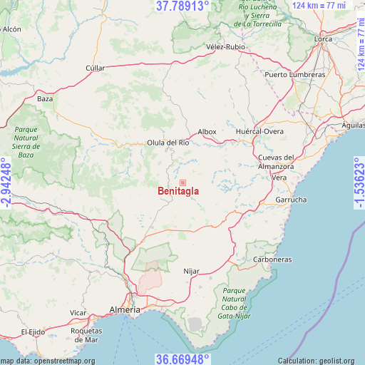
Benitagla GPS coordinates[2]
37° 13' 52.968" North, 2° 14' 21.66" West
| Map corner | latitude | longitude |
|---|---|---|
| Upper-left | 37.78913°, | -2.94248° |
| Center: | 37.23138°, | -2.23935° |
| Lower-right: | 36.66948°, | -1.53623° |
| Map W x H: | 124.5×124.5 km | = 77.4×77.4mi |
| max Lat: | 43.74134° ⇑93.6% North |
| Benitagla: | 37.23138° |
| min Lat: | ⇓6.4% South 27.64134° |
| min Long | Benitagla | max Long |
| -18.00367° | -2.23935° | 4.2899° |
| W 64.3%⇐ | ⇒35.7% E |
Elevation
Elevation of Benitagla is 952 m = 3123 ft, and this is 354 m = 1161 ft above average elevation for this country.
| Max E: |
1682 m = 5518 ft | 14.9% |
| Benitagla | 952 m 3123 ft | |
| Avg. | 598 m = 1962 ft | |
Min E: |
0 m = 0 ft | 85.1% |
See also: Spain elevation on elevation.city.
Geographical zone
Benitagla is located in North temperate zone (between Tropic of Cancer and the Arctic Circle). Distance of this Northern Tropic circle is 1533.8 km =953.1 mi to South.| Distance of | km | miles | from Benitagla |
|---|---|---|---|
| North Pole | 5867.3 | 3645.8 | to North |
| Arctic Circle | 3261.4 | 2026.5 | to North |
| Tropic Cancer | 1533.8 | 953.1 | to South |
| Equator | 4139.7 | 2572.3 | to South |


Nearby cities:
15 places around Benitagla: (largest is in red/bold)
• Albánchez
7.7 km =4.8 mi,  41°
41°
• Alcudia de Monteagud
2.4 km =1.5 mi,  280°
280°
• Benizalón
2.2 km =1.4 mi,  185°
185°
• Cantoria
14 km =8.7 mi,  17°
17°
• Chercos
3.5 km =2.2 mi,  316°
316°
• Cóbdar
4.2 km =2.6 mi, 36°
• Fines
14.5 km =9 mi,  353°
353°
• Laroya
11.2 km =7 mi,  311°
311°
• Lubrín
15.4 km =9.6 mi,  96°
96°
• Macael
12.6 km =7.8 mi,  334°
334°
• Olula del Río
14.6 km =9.1 mi,  339°
339°
• Purchena
16.8 km =10.4 mi, 320°
• Tahal
4 km =2.5 mi,  264°
264°
• Uleila del Campo
6 km =3.7 mi,  149°
149°
• Velefique
15 km =9.3 mi,  253°
253°
Sources, notices
• [Note1] Compared only with cities in Spain existing in our database
• [Src1] Map data: © OpenStreetMap contributors (CC-BY-SA)
• [Src2] Other city data from geonames.org with taken over terms of usage.
• [Src3] Geographical zone / Annual Mean Temperature by Robert A. Rohde @ Wikipedia
