Benisanó geodata
Benisanó (Valencia) is a seat of a third-order administrative division; located in Spain in Europe/Madrid (GMT+2) time zone. With population of 1,974 people, there are 2194 cities with bigger population in this country. Compared to other cities in Spain, 75.5% of cities are located further ↑North; 80.9% of cities are located further ←West and 84.5% of cities have higher elevation than Benisanó. Note1


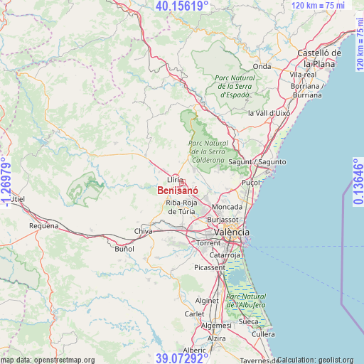
Benisanó GPS coordinates[2]
39° 37' 0.012" North, 0° 34' 0.012" West
| Map corner | latitude | longitude |
|---|---|---|
| Upper-left | 40.15619°, | -1.26979° |
| Center: | 39.61667°, | -0.56667° |
| Lower-right: | 39.07292°, | 0.13646° |
| Map W x H: | 120.4×120.4 km | = 74.8×74.8mi |
| max Lat: | 43.74134° ⇑75.5% North |
| Benisanó: | 39.61667° |
| min Lat: | ⇓24.5% South 27.64134° |
| min Long | Benisanó | max Long |
| -18.00367° | -0.56667° | 4.2899° |
| W 80.9%⇐ | ⇒19.1% E |
Elevation
Elevation of Benisanó is 148 m = 486 ft, and this is 450 m = 1476 ft below average elevation for this country.
| Max E: |
1682 m = 5518 ft | 84.5% |
| Avg. | 598 m = 1962 ft | |
| Benisanó | 148 m = 486 ft | |
Min E: |
0 m = 0 ft | 15.5% |
See also: Spain elevation on elevation.city.
Geographical zone
Benisanó is located in North temperate zone (between Tropic of Cancer and the Arctic Circle). Distance of this Northern Tropic circle is 1799 km =1117.8 mi to South.| Distance of | km | miles | from Benisanó |
|---|---|---|---|
| North Pole | 5602.1 | 3481 | to North |
| Arctic Circle | 2996.2 | 1861.8 | to North |
| Tropic Cancer | 1799 | 1117.8 | to South |
| Equator | 4405 | 2737.1 | to South |


Nearby cities:
15 places around Benisanó: (largest is in red/bold)
• Benaguasil
2.3 km =1.4 mi,  217°
217°
• Bétera
9.4 km =5.8 mi,  107°
107°
• Casinos
14.7 km =9.1 mi,  309°
309°
• Domeño
10.2 km =6.3 mi,  299°
299°
• Godella
15.8 km =9.8 mi,  125°
125°
• L'Eliana
6.3 km =3.9 mi,  152°
152°
• La Pobla de Vallbona
2.4 km =1.5 mi, 154°
• Llíria
3 km =1.9 mi, 297°
• Marines
14.2 km =8.8 mi,  12°
12°
• Náquera
13.4 km =8.3 mi,  73°
73°
• Olocau
9.7 km =6 mi,  17°
17°
• Pedralba
13 km =8.1 mi,  261°
261°
• Ribarroja del Turia
7.9 km =4.9 mi,  182°
182°
• Serra
13.6 km =8.5 mi,  57°
57°
• Vilamarxant
7.2 km =4.5 mi, 223°
Sources, notices
• [Note1] Compared only with cities in Spain existing in our database
• [Src1] Map data: © OpenStreetMap contributors (CC-BY-SA)
• [Src2] Other city data from geonames.org with taken over terms of usage.
• [Src3] Geographical zone / Annual Mean Temperature by Robert A. Rohde @ Wikipedia
