Llíria geodata
Llíria (Valencia) is a populated place; located in Spain in Europe/Madrid (GMT+2) time zone. With population of 22,706 people, there are 410 cities with bigger population in this country. Compared to other cities in Spain, 75.3% of cities are located further ↑North; 80.6% of cities are located further ←West and 82.6% of cities have higher elevation than Llíria. Note1


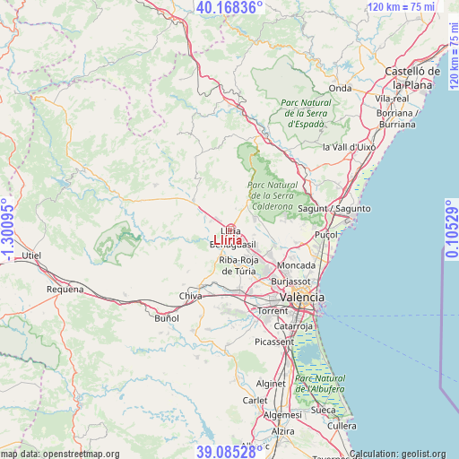
Llíria GPS coordinates[2]
39° 37' 44.184" North, 0° 35' 52.188" West
| Map corner | latitude | longitude |
|---|---|---|
| Upper-left | 40.16836°, | -1.30095° |
| Center: | 39.62894°, | -0.59783° |
| Lower-right: | 39.08528°, | 0.10529° |
| Map W x H: | 120.4×120.4 km | = 74.8×74.8mi |
| max Lat: | 43.74134° ⇑75.3% North |
| Llíria: | 39.62894° |
| min Lat: | ⇓24.7% South 27.64134° |
| min Long | Llíria | max Long |
| -18.00367° | -0.59783° | 4.2899° |
| W 80.6%⇐ | ⇒19.4% E |
Elevation
Elevation of Llíria is 174 m = 571 ft, and this is 424 m = 1391 ft below average elevation for this country.
| Max E: |
1682 m = 5518 ft | 82.6% |
| Avg. | 598 m = 1962 ft | |
| Llíria | 174 m = 571 ft | |
Min E: |
0 m = 0 ft | 17.4% |
See also: Spain elevation on elevation.city.
Geographical zone
Llíria is located in North temperate zone (between Tropic of Cancer and the Arctic Circle). Distance of this Northern Tropic circle is 1800.4 km =1118.7 mi to South.| Distance of | km | miles | from Llíria |
|---|---|---|---|
| North Pole | 5600.7 | 3480.1 | to North |
| Arctic Circle | 2994.8 | 1860.9 | to North |
| Tropic Cancer | 1800.4 | 1118.7 | to South |
| Equator | 4406.3 | 2737.9 | to South |


Nearby cities:
15 places around Llíria: (largest is in red/bold)
• Benaguasil
3.4 km =2.1 mi,  158°
158°
• Benisanó
3 km =1.9 mi,  117°
117°
• Bugarra
14.5 km =9 mi,  264°
264°
• Bétera
12.4 km =7.7 mi,  109°
109°
• Casinos
11.8 km =7.3 mi,  312°
312°
• Domeño
7.2 km =4.5 mi,  299°
299°
• L'Eliana
8.9 km =5.5 mi,  141°
141°
• La Pobla de Vallbona
5.1 km =3.2 mi,  133°
133°
• Marines
13.8 km =8.6 mi,  24°
24°
• Náquera
15.7 km =9.8 mi,  81°
81°
• Olocau
9.6 km =6 mi,  34°
34°
• Pedralba
10.7 km =6.6 mi,  252°
252°
• Ribarroja del Turia
9.5 km =5.9 mi,  165°
165°
• Serra
15.3 km =9.5 mi,  66°
66°
• Vilamarxant
7 km =4.3 mi,  198°
198°
Sources, notices
• [Note1] Compared only with cities in Spain existing in our database
• [Src1] Map data: © OpenStreetMap contributors (CC-BY-SA)
• [Src2] Other city data from geonames.org with taken over terms of usage.
• [Src3] Geographical zone / Annual Mean Temperature by Robert A. Rohde @ Wikipedia
