Bétera geodata
Bétera (Valencia) is a seat of a third-order administrative division; located in Spain in Europe/Madrid (GMT+2) time zone. With population of 20,740 people, there are 464 cities with bigger population in this country. Compared to other cities in Spain, 75.9% of cities are located further ↑North; 82.2% of cities are located further ←West and 87% of cities have higher elevation than Bétera. Note1


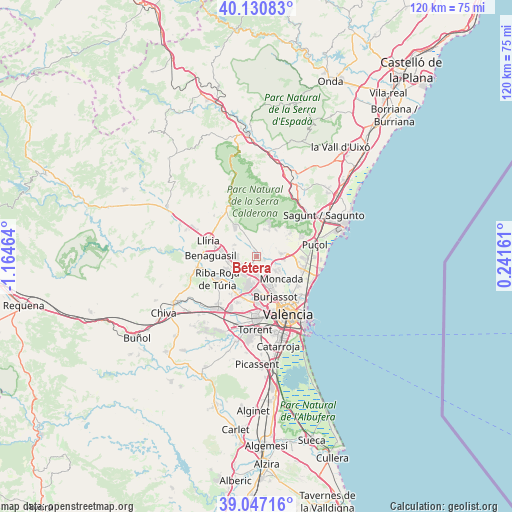
Bétera GPS coordinates[2]
39° 35' 27.996" North, 0° 27' 41.436" West
| Map corner | latitude | longitude |
|---|---|---|
| Upper-left | 40.13083°, | -1.16464° |
| Center: | 39.59111°, | -0.46151° |
| Lower-right: | 39.04716°, | 0.24161° |
| Map W x H: | 120.5×120.5 km | = 74.9×74.9mi |
| max Lat: | 43.74134° ⇑75.9% North |
| Bétera: | 39.59111° |
| min Lat: | ⇓24.1% South 27.64134° |
| min Long | Bétera | max Long |
| -18.00367° | -0.46151° | 4.2899° |
| W 82.2%⇐ | ⇒17.8% E |
Elevation
Elevation of Bétera is 110 m = 361 ft, and this is 488 m = 1601 ft below average elevation for this country.
| Max E: |
1682 m = 5518 ft | 87% |
| Avg. | 598 m = 1962 ft | |
| Bétera | 110 m = 361 ft | |
Min E: |
0 m = 0 ft | 13% |
See also: Spain elevation on elevation.city.
Geographical zone
Bétera is located in North temperate zone (between Tropic of Cancer and the Arctic Circle). Distance of this Northern Tropic circle is 1796.2 km =1116.1 mi to South.| Distance of | km | miles | from Bétera |
|---|---|---|---|
| North Pole | 5604.9 | 3482.7 | to North |
| Arctic Circle | 2999.1 | 1863.6 | to North |
| Tropic Cancer | 1796.2 | 1116.1 | to South |
| Equator | 4402.1 | 2735.3 | to South |


Nearby cities:
15 places around Bétera: (largest is in red/bold)
• Alfara del Patriarca
8.1 km =5 mi,  124°
124°
• Benaguasil
10.5 km =6.5 mi,  275°
275°
• Benisanó
9.4 km =5.8 mi,  287°
287°
• Burjassot
9.9 km =6.2 mi,  155°
155°
• Godella
7.5 km =4.7 mi,  149°
149°
• L'Eliana
6.7 km =4.2 mi,  246°
246°
• La Pobla de Vallbona
8 km =5 mi, 275°
• Moncada
7.6 km =4.7 mi,  131°
131°
• Museros
9.9 km =6.2 mi,  105°
105°
• Náquera
7.6 km =4.7 mi,  30°
30°
• Paterna
10 km =6.2 mi,  169°
169°
• Ribarroja del Turia
10.6 km =6.6 mi,  241°
241°
• Rocafort
8.3 km =5.2 mi,  140°
140°
• Serra
10.5 km =6.5 mi,  13°
13°
• Vinalesa
10.4 km =6.5 mi, 128°
Sources, notices
• [Note1] Compared only with cities in Spain existing in our database
• [Src1] Map data: © OpenStreetMap contributors (CC-BY-SA)
• [Src2] Other city data from geonames.org with taken over terms of usage.
• [Src3] Geographical zone / Annual Mean Temperature by Robert A. Rohde @ Wikipedia
