Punta Umbría geodata
Punta Umbría (Andalusia) is a seat of a third-order administrative division; located in Spain in Europe/Madrid (GMT+2) time zone. With population of 14,708 people, there are 629 cities with bigger population in this country. Compared to other cities in Spain, 94.2% of cities are located further ↑North; 94.1% of cities are located further →East and 98.4% of cities have higher elevation than Punta Umbría. Note1


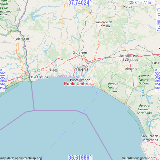
Punta Umbría GPS coordinates[2]
37° 10' 55.668" North, 6° 57' 57.78" West
| Map corner | latitude | longitude |
|---|---|---|
| Upper-left | 37.74024°, | -7.66918° |
| Center: | 37.18213°, | -6.96605° |
| Lower-right: | 36.61986°, | -6.26293° |
| Map W x H: | 124.6×124.6 km | = 77.4×77.4mi |
| max Lat: | 43.74134° ⇑94.2% North |
| Punta Umbría: | 37.18213° |
| min Lat: | ⇓5.8% South 27.64134° |
| min Long | Punta Umbría | max Long |
| -18.00367° | -6.96605° | 4.2899° |
| W 5.9%⇐ | ⇒94.1% E |
Elevation
Elevation of Punta Umbría is 10 m = 33 ft, and this is 588 m = 1929 ft below average elevation for this country.
| Max E: |
1682 m = 5518 ft | 98.4% |
| Avg. | 598 m = 1962 ft | |
| Punta Umbría | 10 m = 33 ft | |
Min E: |
0 m = 0 ft | 1.6% |
See also: Spain elevation on elevation.city.
Geographical zone
Punta Umbría is located in North temperate zone (between Tropic of Cancer and the Arctic Circle). Distance of this Northern Tropic circle is 1528.3 km =949.6 mi to South.| Distance of | km | miles | from Punta Umbría |
|---|---|---|---|
| North Pole | 5872.8 | 3649.2 | to North |
| Arctic Circle | 3266.9 | 2030 | to North |
| Tropic Cancer | 1528.3 | 949.6 | to South |
| Equator | 4134.3 | 2568.9 | to South |


Nearby cities:
15 places around Punta Umbría: (largest is in red/bold)
• Aljaraque
11 km =6.8 mi,  332°
332°
• Bonares
29.8 km =18.5 mi,  57°
57°
• Cartaya
19.7 km =12.2 mi,  303°
303°
• El Rompido
14.4 km =8.9 mi,  285°
285°
• Gibraleón
21.6 km =13.4 mi,  359°
359°
• Huelva
9.6 km =6 mi,  13°
13°
• Islantilla
24.2 km =15 mi,  276°
276°
• La Antilla
21.7 km =13.5 mi, 277°
• Lepe
22.6 km =14 mi, 290°
• Lucena del Puerto
25 km =15.5 mi, 57°
• Mazagón
13.3 km =8.3 mi,  111°
111°
• Moguer
15.3 km =9.5 mi,  47°
47°
• Palos de la Frontera
8.6 km =5.3 mi, 47°
• San Juan del Puerto
18.6 km =11.6 mi,  36°
36°
• Trigueros
25.8 km =16 mi,  28°
28°
Sources, notices
• [Note1] Compared only with cities in Spain existing in our database
• [Src1] Map data: © OpenStreetMap contributors (CC-BY-SA)
• [Src2] Other city data from geonames.org with taken over terms of usage.
• [Src3] Geographical zone / Annual Mean Temperature by Robert A. Rohde @ Wikipedia
