Ronda geodata
Ronda (Andalusia) is a seat of a third-order administrative division; located in Spain in Europe/Madrid (GMT+2) time zone. With population of 36,827 people, there are 241 cities with bigger population in this country. Compared to other cities in Spain, 97.3% of cities are located further ↑North; 74.6% of cities are located further →East and 56.3% of cities have lower elevation than Ronda. Note1


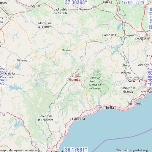
Ronda GPS coordinates[2]
36° 44' 32.316" North, 5° 10' 1.524" West
| Map corner | latitude | longitude |
|---|---|---|
| Upper-left | 37.30368°, | -5.87022° |
| Center: | 36.74231°, | -5.16709° |
| Lower-right: | 36.17681°, | -4.46397° |
| Map W x H: | 125.3×125.3 km | = 77.9×77.9mi |
| max Lat: | 43.74134° ⇑97.3% North |
| Ronda: | 36.74231° |
| min Lat: | ⇓2.7% South 27.64134° |
| min Long | Ronda | max Long |
| -18.00367° | -5.16709° | 4.2899° |
| W 25.4%⇐ | ⇒74.6% E |
Elevation
Elevation of Ronda is 718 m = 2356 ft, and this is 120 m = 394 ft above average elevation for this country.
| Max E: |
1682 m = 5518 ft | 43.7% |
| Ronda | 718 m 2356 ft | |
| Avg. | 598 m = 1962 ft | |
Min E: |
0 m = 0 ft | 56.3% |
See also: Spain elevation on elevation.city.
Geographical zone
Ronda is located in North temperate zone (between Tropic of Cancer and the Arctic Circle). Distance of this Northern Tropic circle is 1479.4 km =919.3 mi to South.| Distance of | km | miles | from Ronda |
|---|---|---|---|
| North Pole | 5921.7 | 3679.6 | to North |
| Arctic Circle | 3315.8 | 2060.3 | to North |
| Tropic Cancer | 1479.4 | 919.3 | to South |
| Equator | 4085.4 | 2538.5 | to South |


Nearby cities:
15 places around Ronda: (largest is in red/bold)
• Alpandeire
12.4 km =7.7 mi,  194°
194°
• Arriate
6.8 km =4.2 mi,  20°
20°
• Atajate
13.4 km =8.3 mi,  211°
211°
• Benaoján
8 km =5 mi,  251°
251°
• Cartajima
10.8 km =6.7 mi,  173°
173°
• Faraján
14.1 km =8.8 mi, 187°
• Grazalema
18 km =11.2 mi,  276°
276°
• Igualeja
12.9 km =8 mi,  161°
161°
• Jimera de Líbar
13.9 km =8.6 mi,  223°
223°
• Júzcar
13.1 km =8.1 mi,  181°
181°
• Montecorto
14.2 km =8.8 mi,  305°
305°
• Montejaque
7.4 km =4.6 mi,  265°
265°
• Parauta
10.1 km =6.3 mi, 160°
• Pujerra
14.5 km =9 mi, 173°
• Setenil de las Bodegas
13.6 km =8.5 mi,  354°
354°
Sources, notices
• [Note1] Compared only with cities in Spain existing in our database
• [Src1] Map data: © OpenStreetMap contributors (CC-BY-SA)
• [Src2] Other city data from geonames.org with taken over terms of usage.
• [Src3] Geographical zone / Annual Mean Temperature by Robert A. Rohde @ Wikipedia
