Jimera de Líbar geodata
Jimera de Líbar (Andalusia) is a seat of a third-order administrative division; located in Spain in Europe/Madrid (GMT+2) time zone. With population of 431 people, there are 4054 cities with bigger population in this country. Compared to other cities in Spain, 97.6% of cities are located further ↑North; 76% of cities are located further →East and 59.4% of cities have higher elevation than Jimera de Líbar. Note1
Administrative division(s):
- Level 1: Andalusia
- Level 2: Provincia de Málaga
- Level 3: Jimera de Líbar


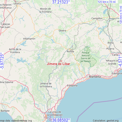
Jimera de Líbar GPS coordinates[2]
36° 39' 4.284" North, 5° 16' 26.832" West
| Map corner | latitude | longitude |
|---|---|---|
| Upper-left | 37.21323°, | -5.97725° |
| Center: | 36.65119°, | -5.27412° |
| Lower-right: | 36.08502°, | -4.571° |
| Map W x H: | 125.4×125.4 km | = 77.9×77.9mi |
| max Lat: | 43.74134° ⇑97.6% North |
| Jimera de Líbar: | 36.65119° |
| min Lat: | ⇓2.4% South 27.64134° |
| min Long | Jimera de Líba | max Long |
| -18.00367° | -5.27412° | 4.2899° |
| W 24%⇐ | ⇒76% E |
Elevation
Elevation of Jimera de Líbar is 535 m = 1755 ft, and this is 63 m = 207 ft below average elevation for this country.
| Max E: |
1682 m = 5518 ft | 59.4% |
| Avg. | 598 m = 1962 ft | |
| Jimera de Líbar | 535 m = 1755 ft | |
Min E: |
0 m = 0 ft | 40.6% |
See also: Spain elevation on elevation.city.
Geographical zone
Jimera de Líbar is located in North temperate zone (between Tropic of Cancer and the Arctic Circle). Distance of this Northern Tropic circle is 1469.3 km =913 mi to South.| Distance of | km | miles | from Jimera de Líbar |
|---|---|---|---|
| North Pole | 5931.8 | 3685.8 | to North |
| Arctic Circle | 3325.9 | 2066.6 | to North |
| Tropic Cancer | 1469.3 | 913 | to South |
| Equator | 4075.2 | 2532.2 | to South |


Nearby cities:
15 places around Jimera de Líbar: (largest is in red/bold)
• Algatocín
8.6 km =5.3 mi,  180°
180°
• Alpandeire
6.7 km =4.2 mi,  106°
106°
• Atajate
2.8 km =1.7 mi,  116°
116°
• Benalauría
6.4 km =4 mi,  169°
169°
• Benaoján
7.8 km =4.8 mi,  14°
14°
• Benarrabá
11.1 km =6.9 mi, 180°
• Cartajima
10.7 km =6.6 mi,  93°
93°
• Cortes de la Frontera
7.2 km =4.5 mi,  238°
238°
• Faraján
8.5 km =5.3 mi, 116°
• Genalguacil
12.2 km =7.6 mi,  163°
163°
• Jubrique
10.9 km =6.8 mi,  151°
151°
• Júzcar
9.8 km =6.1 mi, 107°
• Montejaque
9.8 km =6.1 mi, 12°
• Pujerra
11.9 km =7.4 mi, 111°
• Villaluenga del Rosario
11.2 km =7 mi,  296°
296°
Sources, notices
• [Note1] Compared only with cities in Spain existing in our database
• [Src1] Map data: © OpenStreetMap contributors (CC-BY-SA)
• [Src2] Other city data from geonames.org with taken over terms of usage.
• [Src3] Geographical zone / Annual Mean Temperature by Robert A. Rohde @ Wikipedia
