Alpandeire geodata
Alpandeire (Andalusia) is a seat of a third-order administrative division; located in Spain in Europe/Madrid (GMT+2) time zone. With population of 285 people, there are 4564 cities with bigger population in this country. Compared to other cities in Spain, 97.7% of cities are located further ↑North; 75.1% of cities are located further →East and 54.2% of cities have lower elevation than Alpandeire. Note1


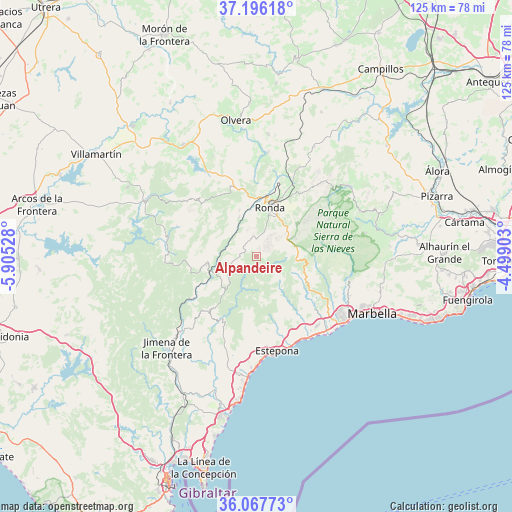
Alpandeire GPS coordinates[2]
36° 38' 2.472" North, 5° 12' 7.776" West
| Map corner | latitude | longitude |
|---|---|---|
| Upper-left | 37.19618°, | -5.90528° |
| Center: | 36.63402°, | -5.20216° |
| Lower-right: | 36.06773°, | -4.49903° |
| Map W x H: | 125.5×125.5 km | = 78×78mi |
| max Lat: | 43.74134° ⇑97.7% North |
| Alpandeire: | 36.63402° |
| min Lat: | ⇓2.3% South 27.64134° |
| min Long | Alpandeire | max Long |
| -18.00367° | -5.20216° | 4.2899° |
| W 24.9%⇐ | ⇒75.1% E |
Elevation
Elevation of Alpandeire is 702 m = 2303 ft, and this is 104 m = 341 ft above average elevation for this country.
| Max E: |
1682 m = 5518 ft | 45.8% |
| Alpandeire | 702 m 2303 ft | |
| Avg. | 598 m = 1962 ft | |
Min E: |
0 m = 0 ft | 54.2% |
See also: Spain elevation on elevation.city.
Geographical zone
Alpandeire is located in North temperate zone (between Tropic of Cancer and the Arctic Circle). Distance of this Northern Tropic circle is 1467.4 km =911.8 mi to South.| Distance of | km | miles | from Alpandeire |
|---|---|---|---|
| North Pole | 5933.7 | 3687 | to North |
| Arctic Circle | 3327.9 | 2067.9 | to North |
| Tropic Cancer | 1467.4 | 911.8 | to South |
| Equator | 4073.3 | 2531 | to South |


Nearby cities:
15 places around Alpandeire: (largest is in red/bold)
• Algatocín
9.4 km =5.8 mi,  224°
224°
• Atajate
4 km =2.5 mi,  279°
279°
• Benalauría
6.9 km =4.3 mi,  230°
230°
• Benaoján
10.5 km =6.5 mi,  334°
334°
• Benarrabá
11.3 km =7 mi, 215°
• Cartajima
4.5 km =2.8 mi,  73°
73°
• Faraján
2.3 km =1.4 mi,  147°
147°
• Genalguacil
10.3 km =6.4 mi,  196°
196°
• Igualeja
7.2 km =4.5 mi,  91°
91°
• Jimera de Líbar
6.7 km =4.2 mi,  286°
286°
• Jubrique
7.8 km =4.8 mi,  188°
188°
• Júzcar
3.1 km =1.9 mi,  110°
110°
• Montejaque
12.2 km =7.6 mi,  339°
339°
• Parauta
7 km =4.3 mi, 69°
• Pujerra
5.2 km =3.2 mi,  116°
116°
Sources, notices
• [Note1] Compared only with cities in Spain existing in our database
• [Src1] Map data: © OpenStreetMap contributors (CC-BY-SA)
• [Src2] Other city data from geonames.org with taken over terms of usage.
• [Src3] Geographical zone / Annual Mean Temperature by Robert A. Rohde @ Wikipedia
