Benaoján geodata
Benaoján (Andalusia) is a seat of a third-order administrative division; located in Spain in Europe/Madrid (GMT+2) time zone. With population of 1,661 people, there are 2364 cities with bigger population in this country. Compared to other cities in Spain, 97.4% of cities are located further ↑North; 75.7% of cities are located further →East and 57.4% of cities have higher elevation than Benaoján. Note1


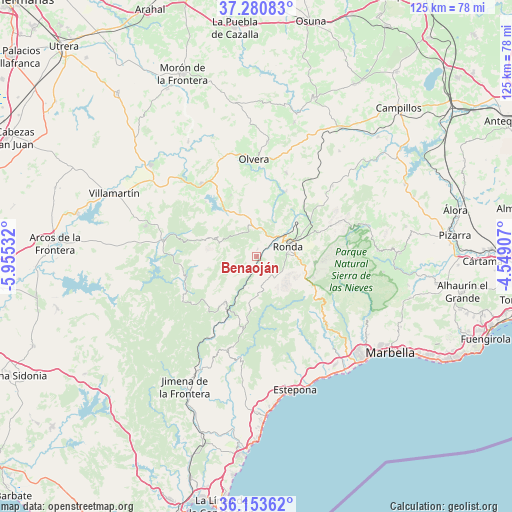
Benaoján GPS coordinates[2]
36° 43' 9.444" North, 5° 15' 7.92" West
| Map corner | latitude | longitude |
|---|---|---|
| Upper-left | 37.28083°, | -5.95532° |
| Center: | 36.71929°, | -5.2522° |
| Lower-right: | 36.15362°, | -4.54907° |
| Map W x H: | 125.3×125.3 km | = 77.9×77.9mi |
| max Lat: | 43.74134° ⇑97.4% North |
| Benaoján: | 36.71929° |
| min Lat: | ⇓2.6% South 27.64134° |
| min Long | Benaoján | max Long |
| -18.00367° | -5.2522° | 4.2899° |
| W 24.3%⇐ | ⇒75.7% E |
Elevation
Elevation of Benaoján is 558 m = 1831 ft, and this is 40 m = 131 ft below average elevation for this country.
| Max E: |
1682 m = 5518 ft | 57.4% |
| Avg. | 598 m = 1962 ft | |
| Benaoján | 558 m = 1831 ft | |
Min E: |
0 m = 0 ft | 42.6% |
See also: Spain elevation on elevation.city.
Geographical zone
Benaoján is located in North temperate zone (between Tropic of Cancer and the Arctic Circle). Distance of this Northern Tropic circle is 1476.9 km =917.7 mi to South.| Distance of | km | miles | from Benaoján |
|---|---|---|---|
| North Pole | 5924.3 | 3681.2 | to North |
| Arctic Circle | 3318.4 | 2062 | to North |
| Tropic Cancer | 1476.9 | 917.7 | to South |
| Equator | 4082.8 | 2536.9 | to South |


Nearby cities:
15 places around Benaoján: (largest is in red/bold)
• Alpandeire
10.5 km =6.5 mi,  154°
154°
• Arriate
13.4 km =8.3 mi,  47°
47°
• Atajate
8.8 km =5.5 mi,  176°
176°
• Benalauría
13.9 km =8.6 mi, 183°
• Cartajima
12 km =7.5 mi,  133°
133°
• Cortes de la Frontera
13.9 km =8.6 mi,  215°
215°
• Faraján
12.7 km =7.9 mi, 153°
• Grazalema
11.3 km =7 mi,  293°
293°
• Jimera de Líbar
7.8 km =4.8 mi,  194°
194°
• Júzcar
12.9 km =8 mi, 145°
• Montecorto
11.5 km =7.1 mi,  339°
339°
• Montejaque
2 km =1.2 mi,  5°
5°
• Parauta
13 km =8.1 mi,  122°
122°
• Ronda
8 km =5 mi,  71°
71°
• Villaluenga del Rosario
12.2 km =7.6 mi,  257°
257°
Sources, notices
• [Note1] Compared only with cities in Spain existing in our database
• [Src1] Map data: © OpenStreetMap contributors (CC-BY-SA)
• [Src2] Other city data from geonames.org with taken over terms of usage.
• [Src3] Geographical zone / Annual Mean Temperature by Robert A. Rohde @ Wikipedia
