Huécija geodata
Huécija (Andalusia) is a seat of a third-order administrative division; located in Spain in Europe/Madrid (GMT+2) time zone. With population of 550 people, there are 3739 cities with bigger population in this country. Compared to other cities in Spain, 95.6% of cities are located further ↑North; 59.8% of cities are located further ←West and 68.3% of cities have higher elevation than Huécija. Note1


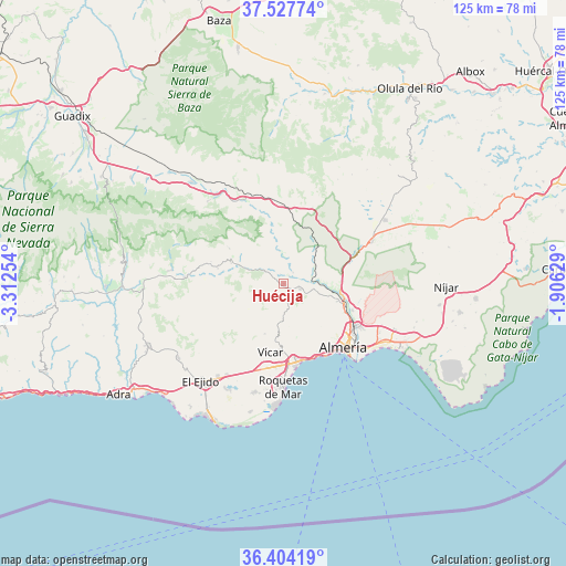
Huécija GPS coordinates[2]
36° 58' 4.944" North, 2° 36' 33.876" West
| Map corner | latitude | longitude |
|---|---|---|
| Upper-left | 37.52774°, | -3.31254° |
| Center: | 36.96804°, | -2.60941° |
| Lower-right: | 36.40419°, | -1.90629° |
| Map W x H: | 124.9×124.9 km | = 77.6×77.6mi |
| max Lat: | 43.74134° ⇑95.6% North |
| Huécija: | 36.96804° |
| min Lat: | ⇓4.4% South 27.64134° |
| min Long | Huécija | max Long |
| -18.00367° | -2.60941° | 4.2899° |
| W 59.8%⇐ | ⇒40.2% E |
Elevation
Elevation of Huécija is 411 m = 1348 ft, and this is 187 m = 614 ft below average elevation for this country.
| Max E: |
1682 m = 5518 ft | 68.3% |
| Avg. | 598 m = 1962 ft | |
| Huécija | 411 m = 1348 ft | |
Min E: |
0 m = 0 ft | 31.7% |
See also: Spain elevation on elevation.city.
Geographical zone
Huécija is located in North temperate zone (between Tropic of Cancer and the Arctic Circle). Distance of this Northern Tropic circle is 1504.5 km =934.9 mi to South.| Distance of | km | miles | from Huécija |
|---|---|---|---|
| North Pole | 5896.6 | 3664 | to North |
| Arctic Circle | 3290.7 | 2044.7 | to North |
| Tropic Cancer | 1504.5 | 934.9 | to South |
| Equator | 4110.5 | 2554.1 | to South |


Nearby cities:
15 places around Huécija: (largest is in red/bold)
• Albolodúy
7.4 km =4.6 mi,  351°
351°
• Alhabia
3.2 km =2 mi,  39°
39°
• Alhama de Almería
3.8 km =2.4 mi,  108°
108°
• Alicún
0.7 km =0.4 mi, 111°
• Alsodux
4 km =2.5 mi,  18°
18°
• Bentarique
2.4 km =1.5 mi,  337°
337°
• Canjáyar
12.4 km =7.7 mi,  291°
291°
• Enix
10.1 km =6.3 mi,  176°
176°
• Félix
11.8 km =7.3 mi,  201°
201°
• Gádor
10.5 km =6.5 mi,  99°
99°
• Illar
3.3 km =2.1 mi,  306°
306°
• Instinción
5.3 km =3.3 mi,  301°
301°
• Rágol
7.1 km =4.4 mi, 295°
• Santa Fe de Mondújar
7 km =4.3 mi,  83°
83°
• Terque
2.1 km =1.3 mi,  32°
32°
Sources, notices
• [Note1] Compared only with cities in Spain existing in our database
• [Src1] Map data: © OpenStreetMap contributors (CC-BY-SA)
• [Src2] Other city data from geonames.org with taken over terms of usage.
• [Src3] Geographical zone / Annual Mean Temperature by Robert A. Rohde @ Wikipedia
