Santa Fe de Mondújar geodata
Santa Fe de Mondújar (Andalusia) is a seat of a third-order administrative division; located in Spain in Europe/Madrid (GMT+2) time zone. With population of 429 people, there are 4059 cities with bigger population in this country. Compared to other cities in Spain, 95.5% of cities are located further ↑North; 60.6% of cities are located further ←West and 79.2% of cities have higher elevation than Santa Fe de Mondújar. Note1


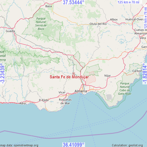
Santa Fe de Mondújar GPS coordinates[2]
36° 58' 29.244" North, 2° 31' 52.536" West
| Map corner | latitude | longitude |
|---|---|---|
| Upper-left | 37.53444°, | -3.23439° |
| Center: | 36.97479°, | -2.53126° |
| Lower-right: | 36.41099°, | -1.82814° |
| Map W x H: | 124.9×124.9 km | = 77.6×77.6mi |
| max Lat: | 43.74134° ⇑95.5% North |
| Santa Fe de Mondújar: | 36.97479° |
| min Lat: | ⇓4.5% South 27.64134° |
| min Long | Santa Fe de Mon | max Long |
| -18.00367° | -2.53126° | 4.2899° |
| W 60.6%⇐ | ⇒39.4% E |
Elevation
Elevation of Santa Fe de Mondújar is 235 m = 771 ft, and this is 363 m = 1191 ft below average elevation for this country.
| Max E: |
1682 m = 5518 ft | 79.2% |
| Avg. | 598 m = 1962 ft | |
| Santa Fe de Mondújar | 235 m = 771 ft | |
Min E: |
0 m = 0 ft | 20.8% |
See also: Spain elevation on elevation.city.
Geographical zone
Santa Fe de Mondújar is located in North temperate zone (between Tropic of Cancer and the Arctic Circle). Distance of this Northern Tropic circle is 1505.3 km =935.3 mi to South.| Distance of | km | miles | from Santa Fe de Mondújar |
|---|---|---|---|
| North Pole | 5895.9 | 3663.5 | to North |
| Arctic Circle | 3290 | 2044.3 | to North |
| Tropic Cancer | 1505.3 | 935.3 | to South |
| Equator | 4111.2 | 2554.6 | to South |


Nearby cities:
15 places around Santa Fe de Mondújar: (largest is in red/bold)
• Albolodúy
10.3 km =6.4 mi,  309°
309°
• Alhabia
5.2 km =3.2 mi,  289°
289°
• Alhama de Almería
3.9 km =2.4 mi,  239°
239°
• Alicún
6.4 km =4 mi,  260°
260°
• Alsodux
6.4 km =4 mi,  298°
298°
• Benahadux
8.5 km =5.3 mi,  130°
130°
• Bentarique
8 km =5 mi,  280°
280°
• Enix
12.5 km =7.8 mi,  210°
210°
• Gádor
4.2 km =2.6 mi,  124°
124°
• Huécija
7 km =4.3 mi, 263°
• Illar
9.6 km =6 mi, 277°
• Instinción
11.7 km =7.3 mi, 280°
• Pechina
10.6 km =6.6 mi, 127°
• Rioja
6.9 km =4.3 mi, 118°
• Terque
5.9 km =3.7 mi, 279°
Sources, notices
• [Note1] Compared only with cities in Spain existing in our database
• [Src1] Map data: © OpenStreetMap contributors (CC-BY-SA)
• [Src2] Other city data from geonames.org with taken over terms of usage.
• [Src3] Geographical zone / Annual Mean Temperature by Robert A. Rohde @ Wikipedia
