Canjáyar geodata
Canjáyar (Andalusia) is a seat of a third-order administrative division; located in Spain in Europe/Madrid (GMT+2) time zone. With population of 1,568 people, there are 2411 cities with bigger population in this country. Compared to other cities in Spain, 95.1% of cities are located further ↑North; 58.2% of cities are located further ←West and 54.4% of cities have higher elevation than Canjáyar. Note1


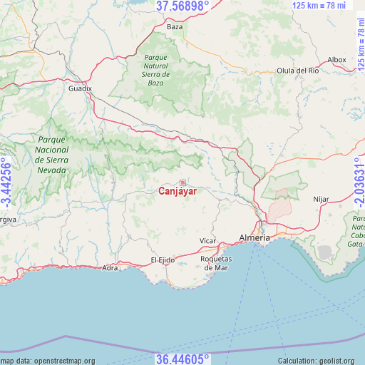
Canjáyar GPS coordinates[2]
37° 0' 34.524" North, 2° 44' 21.948" West
| Map corner | latitude | longitude |
|---|---|---|
| Upper-left | 37.56898°, | -3.44256° |
| Center: | 37.00959°, | -2.73943° |
| Lower-right: | 36.44605°, | -2.03631° |
| Map W x H: | 124.9×124.9 km | = 77.6×77.6mi |
| max Lat: | 43.74134° ⇑95.1% North |
| Canjáyar: | 37.00959° |
| min Lat: | ⇓4.9% South 27.64134° |
| min Long | Canjáyar | max Long |
| -18.00367° | -2.73943° | 4.2899° |
| W 58.2%⇐ | ⇒41.8% E |
Elevation
Elevation of Canjáyar is 604 m = 1982 ft, and this is 6 m = 20 ft above average elevation for this country.
| Max E: |
1682 m = 5518 ft | 54.4% |
| Canjáyar | 604 m 1982 ft | |
| Avg. | 598 m = 1962 ft | |
Min E: |
0 m = 0 ft | 45.6% |
See also: Spain elevation on elevation.city.
Geographical zone
Canjáyar is located in North temperate zone (between Tropic of Cancer and the Arctic Circle). Distance of this Northern Tropic circle is 1509.2 km =937.8 mi to South.| Distance of | km | miles | from Canjáyar |
|---|---|---|---|
| North Pole | 5892 | 3661.1 | to North |
| Arctic Circle | 3286.1 | 2041.9 | to North |
| Tropic Cancer | 1509.2 | 937.8 | to South |
| Equator | 4115.1 | 2557 | to South |


Nearby cities:
15 places around Canjáyar: (largest is in red/bold)
• Albolodúy
10.8 km =6.7 mi,  75°
75°
• Alicún
13.1 km =8.1 mi,  111°
111°
• Almócita
4.6 km =2.9 mi,  260°
260°
• Alsodux
12.9 km =8 mi,  93°
93°
• Beires
4.6 km =2.9 mi,  273°
273°
• Bentarique
10.9 km =6.8 mi,  102°
102°
• Fondón
11.2 km =7 mi,  252°
252°
• Huécija
12.4 km =7.7 mi, 111°
• Illar
9.3 km =5.8 mi, 106°
• Instinción
7.2 km =4.5 mi, 104°
• Laujar de Andarax
13.5 km =8.4 mi, 263°
• Ohanes
3.3 km =2.1 mi,  350°
350°
• Padules
3.3 km =2.1 mi, 247°
• Rágol
5.4 km =3.4 mi, 107°
• Terque
13 km =8.1 mi, 102°
Sources, notices
• [Note1] Compared only with cities in Spain existing in our database
• [Src1] Map data: © OpenStreetMap contributors (CC-BY-SA)
• [Src2] Other city data from geonames.org with taken over terms of usage.
• [Src3] Geographical zone / Annual Mean Temperature by Robert A. Rohde @ Wikipedia
