Terque geodata
Terque (Andalusia) is a seat of a third-order administrative division; located in Spain in Europe/Madrid (GMT+2) time zone. With population of 447 people, there are 4012 cities with bigger population in this country. Compared to other cities in Spain, 95.4% of cities are located further ↑North; 59.9% of cities are located further ←West and 75.4% of cities have higher elevation than Terque. Note1


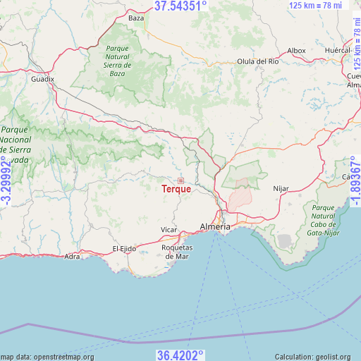
Terque GPS coordinates[2]
36° 59' 2.148" North, 2° 35' 48.444" West
| Map corner | latitude | longitude |
|---|---|---|
| Upper-left | 37.54351°, | -3.29992° |
| Center: | 36.98393°, | -2.59679° |
| Lower-right: | 36.4202°, | -1.89367° |
| Map W x H: | 124.9×124.9 km | = 77.6×77.6mi |
| max Lat: | 43.74134° ⇑95.4% North |
| Terque: | 36.98393° |
| min Lat: | ⇓4.6% South 27.64134° |
| min Long | Terque | max Long |
| -18.00367° | -2.59679° | 4.2899° |
| W 59.9%⇐ | ⇒40.1% E |
Elevation
Elevation of Terque is 293 m = 961 ft, and this is 305 m = 1001 ft below average elevation for this country.
| Max E: |
1682 m = 5518 ft | 75.4% |
| Avg. | 598 m = 1962 ft | |
| Terque | 293 m = 961 ft | |
Min E: |
0 m = 0 ft | 24.6% |
See also: Spain elevation on elevation.city.
Geographical zone
Terque is located in North temperate zone (between Tropic of Cancer and the Arctic Circle). Distance of this Northern Tropic circle is 1506.3 km =936 mi to South.| Distance of | km | miles | from Terque |
|---|---|---|---|
| North Pole | 5894.8 | 3662.9 | to North |
| Arctic Circle | 3288.9 | 2043.6 | to North |
| Tropic Cancer | 1506.3 | 936 | to South |
| Equator | 4112.2 | 2555.2 | to South |


Nearby cities:
15 places around Terque: (largest is in red/bold)
• Albolodúy
5.9 km =3.7 mi,  338°
338°
• Alhabia
1.1 km =0.7 mi,  53°
53°
• Alhama de Almería
3.9 km =2.4 mi,  140°
140°
• Alicún
2.1 km =1.3 mi,  193°
193°
• Alsodux
2.1 km =1.3 mi,  4°
4°
• Bentarique
2.1 km =1.3 mi,  283°
283°
• Canjáyar
13 km =8.1 mi, 282°
• Enix
11.9 km =7.4 mi,  182°
182°
• Gádor
9.9 km =6.2 mi,  110°
110°
• Huécija
2.1 km =1.3 mi,  212°
212°
• Illar
3.7 km =2.3 mi,  272°
272°
• Instinción
5.8 km =3.6 mi, 280°
• Rioja
12.6 km =7.8 mi, 109°
• Rágol
7.7 km =4.8 mi, 279°
• Santa Fe de Mondújar
5.9 km =3.7 mi,  99°
99°
Sources, notices
• [Note1] Compared only with cities in Spain existing in our database
• [Src1] Map data: © OpenStreetMap contributors (CC-BY-SA)
• [Src2] Other city data from geonames.org with taken over terms of usage.
• [Src3] Geographical zone / Annual Mean Temperature by Robert A. Rohde @ Wikipedia
