Albolodúy geodata
Albolodúy (Andalusia) is a populated place; located in Spain in Europe/Madrid (GMT+2) time zone. With population of 763 people, there are 3284 cities with bigger population in this country. Compared to other cities in Spain, 95% of cities are located further ↑North; 59.6% of cities are located further ←West and 69.8% of cities have higher elevation than Albolodúy. Note1


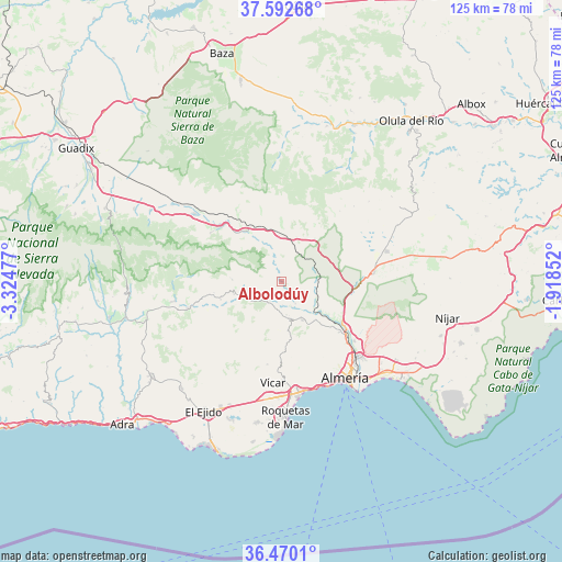
Albolodúy GPS coordinates[2]
37° 2' 0.456" North, 2° 37' 17.904" West
| Map corner | latitude | longitude |
|---|---|---|
| Upper-left | 37.59268°, | -3.32477° |
| Center: | 37.03346°, | -2.62164° |
| Lower-right: | 36.4701°, | -1.91852° |
| Map W x H: | 124.8×124.8 km | = 77.5×77.5mi |
| max Lat: | 43.74134° ⇑95% North |
| Albolodúy: | 37.03346° |
| min Lat: | ⇓5% South 27.64134° |
| min Long | Albolodúy | max Long |
| -18.00367° | -2.62164° | 4.2899° |
| W 59.6%⇐ | ⇒40.4% E |
Elevation
Elevation of Albolodúy is 385 m = 1263 ft, and this is 213 m = 699 ft below average elevation for this country.
| Max E: |
1682 m = 5518 ft | 69.8% |
| Avg. | 598 m = 1962 ft | |
| Albolodúy | 385 m = 1263 ft | |
Min E: |
0 m = 0 ft | 30.2% |
See also: Spain elevation on elevation.city.
Geographical zone
Albolodúy is located in North temperate zone (between Tropic of Cancer and the Arctic Circle). Distance of this Northern Tropic circle is 1511.8 km =939.4 mi to South.| Distance of | km | miles | from Albolodúy |
|---|---|---|---|
| North Pole | 5889.3 | 3659.4 | to North |
| Arctic Circle | 3283.4 | 2040.2 | to North |
| Tropic Cancer | 1511.8 | 939.4 | to South |
| Equator | 4117.7 | 2558.6 | to South |


Nearby cities:
15 places around Albolodúy: (largest is in red/bold)
• Alhabia
5.7 km =3.5 mi,  147°
147°
• Alhama de Almería
9.7 km =6 mi, 151°
• Alicún
7.7 km =4.8 mi,  167°
167°
• Alsodux
4.2 km =2.6 mi, 145°
• Bentarique
5 km =3.1 mi,  178°
178°
• Canjáyar
10.8 km =6.7 mi,  255°
255°
• Gérgal
11.9 km =7.4 mi,  37°
37°
• Huécija
7.4 km =4.6 mi, 171°
• Illar
5.5 km =3.4 mi,  195°
195°
• Instinción
5.6 km =3.5 mi,  217°
217°
• Ohanes
11 km =6.8 mi,  272°
272°
• Padules
14.1 km =8.8 mi,  253°
253°
• Rágol
6.8 km =4.2 mi,  231°
231°
• Santa Fe de Mondújar
10.3 km =6.4 mi,  129°
129°
• Terque
5.9 km =3.7 mi,  158°
158°
Sources, notices
• [Note1] Compared only with cities in Spain existing in our database
• [Src1] Map data: © OpenStreetMap contributors (CC-BY-SA)
• [Src2] Other city data from geonames.org with taken over terms of usage.
• [Src3] Geographical zone / Annual Mean Temperature by Robert A. Rohde @ Wikipedia
