Alhabia geodata
Alhabia (Andalusia) is a seat of a third-order administrative division; located in Spain in Europe/Madrid (GMT+2) time zone. With population of 681 people, there are 3433 cities with bigger population in this country. Compared to other cities in Spain, 95.4% of cities are located further ↑North; 60% of cities are located further ←West and 74.8% of cities have higher elevation than Alhabia. Note1


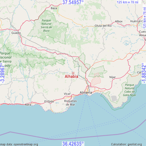
Alhabia GPS coordinates[2]
36° 59' 24.108" North, 2° 35' 11.58" West
| Map corner | latitude | longitude |
|---|---|---|
| Upper-left | 37.54957°, | -3.28967° |
| Center: | 36.99003°, | -2.58655° |
| Lower-right: | 36.42635°, | -1.88342° |
| Map W x H: | 124.9×124.9 km | = 77.6×77.6mi |
| max Lat: | 43.74134° ⇑95.4% North |
| Alhabia: | 36.99003° |
| min Lat: | ⇓4.6% South 27.64134° |
| min Long | Alhabia | max Long |
| -18.00367° | -2.58655° | 4.2899° |
| W 60%⇐ | ⇒40% E |
Elevation
Elevation of Alhabia is 298 m = 978 ft, and this is 300 m = 984 ft below average elevation for this country.
| Max E: |
1682 m = 5518 ft | 74.8% |
| Avg. | 598 m = 1962 ft | |
| Alhabia | 298 m = 978 ft | |
Min E: |
0 m = 0 ft | 25.2% |
See also: Spain elevation on elevation.city.
Geographical zone
Alhabia is located in North temperate zone (between Tropic of Cancer and the Arctic Circle). Distance of this Northern Tropic circle is 1507 km =936.4 mi to South.| Distance of | km | miles | from Alhabia |
|---|---|---|---|
| North Pole | 5894.2 | 3662.5 | to North |
| Arctic Circle | 3288.3 | 2043.3 | to North |
| Tropic Cancer | 1507 | 936.4 | to South |
| Equator | 4112.9 | 2555.6 | to South |


Nearby cities:
15 places around Alhabia: (largest is in red/bold)
• Albolodúy
5.7 km =3.5 mi,  327°
327°
• Alhama de Almería
4 km =2.5 mi,  156°
156°
• Alicún
3 km =1.9 mi,  207°
207°
• Alsodux
1.6 km =1 mi, 332°
• Benahadux
13.4 km =8.3 mi,  122°
122°
• Bentarique
3 km =1.9 mi,  266°
266°
• Enix
12.6 km =7.8 mi,  186°
186°
• Gádor
9.3 km =5.8 mi, 116°
• Huécija
3.2 km =2 mi,  219°
219°
• Illar
4.7 km =2.9 mi,  263°
263°
• Instinción
6.6 km =4.1 mi, 273°
• Rioja
12.1 km =7.5 mi,  114°
114°
• Rágol
8.5 km =5.3 mi, 273°
• Santa Fe de Mondújar
5.2 km =3.2 mi, 109°
• Terque
1.1 km =0.7 mi,  233°
233°
Sources, notices
• [Note1] Compared only with cities in Spain existing in our database
• [Src1] Map data: © OpenStreetMap contributors (CC-BY-SA)
• [Src2] Other city data from geonames.org with taken over terms of usage.
• [Src3] Geographical zone / Annual Mean Temperature by Robert A. Rohde @ Wikipedia
