Hinojosa del Duque geodata
Hinojosa del Duque (Andalusia) is a seat of a third-order administrative division; located in Spain in Europe/Madrid (GMT+2) time zone. With population of 7,555 people, there are 975 cities with bigger population in this country. Compared to other cities in Spain, 85.7% of cities are located further ↑North; 74.4% of cities are located further →East and 58.1% of cities have higher elevation than Hinojosa del Duque. Note1
Administrative division(s):
- Level 1: Andalusia
- Level 2: Province of Córdoba
- Level 3: Hinojosa del Duque


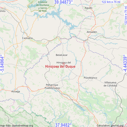
Hinojosa del Duque GPS coordinates[2]
38° 30' 2.052" North, 5° 8' 47.436" West
| Map corner | latitude | longitude |
|---|---|---|
| Upper-left | 39.04873°, | -5.84964° |
| Center: | 38.50057°, | -5.14651° |
| Lower-right: | 37.9482°, | -4.44339° |
| Map W x H: | 122.4×122.4 km | = 76.1×76.1mi |
| max Lat: | 43.74134° ⇑85.7% North |
| Hinojosa del Duque: | 38.50057° |
| min Lat: | ⇓14.3% South 27.64134° |
| min Long | Hinojosa del Du | max Long |
| -18.00367° | -5.14651° | 4.2899° |
| W 25.6%⇐ | ⇒74.4% E |
Elevation
Elevation of Hinojosa del Duque is 551 m = 1808 ft, and this is 47 m = 154 ft below average elevation for this country.
| Max E: |
1682 m = 5518 ft | 58.1% |
| Avg. | 598 m = 1962 ft | |
| Hinojosa del Duque | 551 m = 1808 ft | |
Min E: |
0 m = 0 ft | 41.9% |
See also: Spain elevation on elevation.city.
Geographical zone
Hinojosa del Duque is located in North temperate zone (between Tropic of Cancer and the Arctic Circle). Distance of this Northern Tropic circle is 1674.9 km =1040.7 mi to South.| Distance of | km | miles | from Hinojosa del Duque |
|---|---|---|---|
| North Pole | 5726.2 | 3558.1 | to North |
| Arctic Circle | 3120.3 | 1938.9 | to North |
| Tropic Cancer | 1674.9 | 1040.7 | to South |
| Equator | 4280.9 | 2660 | to South |


Nearby cities:
15 places around Hinojosa del Duque: (largest is in red/bold)
• Alcaracejos
20.4 km =12.7 mi,  129°
129°
• Añora
23.4 km =14.5 mi,  113°
113°
• Belalcázar
8.5 km =5.3 mi,  348°
348°
• Blázquez
27.4 km =17 mi,  245°
245°
• Bélmez
26.4 km =16.4 mi,  190°
190°
• Cabeza del Buey
25.5 km =15.8 mi, 345°
• Dos Torres
22.2 km =13.8 mi,  104°
104°
• El Viso
17.2 km =10.7 mi, 96°
• Fuente la Lancha
13.6 km =8.5 mi, 133°
• Monterrubio de la Serena
27.8 km =17.3 mi,  290°
290°
• Peñarroya-Pueblonuevo
24.6 km =15.3 mi,  205°
205°
• Pozoblanco
29.3 km =18.2 mi,  117°
117°
• Santa Eufemia
24.1 km =15 mi,  62°
62°
• Villanueva del Duque
18.2 km =11.3 mi,  135°
135°
• Villaralto
15.3 km =9.5 mi, 111°
Sources, notices
• [Note1] Compared only with cities in Spain existing in our database
• [Src1] Map data: © OpenStreetMap contributors (CC-BY-SA)
• [Src2] Other city data from geonames.org with taken over terms of usage.
• [Src3] Geographical zone / Annual Mean Temperature by Robert A. Rohde @ Wikipedia
