Belalcázar geodata
Belalcázar (Andalusia) is a seat of a third-order administrative division; located in Spain in Europe/Madrid (GMT+2) time zone. With population of 3,562 people, there are 1573 cities with bigger population in this country. Compared to other cities in Spain, 85.2% of cities are located further ↑North; 74.6% of cities are located further →East and 62.5% of cities have higher elevation than Belalcázar. Note1


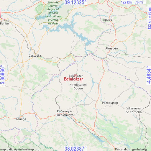
Belalcázar GPS coordinates[2]
38° 34' 32.376" North, 5° 9' 59.508" West
| Map corner | latitude | longitude |
|---|---|---|
| Upper-left | 39.12325°, | -5.86966° |
| Center: | 38.57566°, | -5.16653° |
| Lower-right: | 38.02387°, | -4.4634° |
| Map W x H: | 122.2×122.2 km | = 75.9×75.9mi |
| max Lat: | 43.74134° ⇑85.2% North |
| Belalcázar: | 38.57566° |
| min Lat: | ⇓14.8% South 27.64134° |
| min Long | Belalcázar | max Long |
| -18.00367° | -5.16653° | 4.2899° |
| W 25.4%⇐ | ⇒74.6% E |
Elevation
Elevation of Belalcázar is 492 m = 1614 ft, and this is 106 m = 348 ft below average elevation for this country.
| Max E: |
1682 m = 5518 ft | 62.5% |
| Avg. | 598 m = 1962 ft | |
| Belalcázar | 492 m = 1614 ft | |
Min E: |
0 m = 0 ft | 37.5% |
See also: Spain elevation on elevation.city.
Geographical zone
Belalcázar is located in North temperate zone (between Tropic of Cancer and the Arctic Circle). Distance of this Northern Tropic circle is 1683.3 km =1046 mi to South.| Distance of | km | miles | from Belalcázar |
|---|---|---|---|
| North Pole | 5717.9 | 3552.9 | to North |
| Arctic Circle | 3112 | 1933.7 | to North |
| Tropic Cancer | 1683.3 | 1046 | to South |
| Equator | 4289.2 | 2665.2 | to South |


Nearby cities:
15 places around Belalcázar: (largest is in red/bold)
• Alcaracejos
27.6 km =17.1 mi,  140°
140°
• Añora
29.2 km =18.1 mi,  127°
127°
• Blázquez
30.3 km =18.8 mi,  229°
229°
• Cabeza del Buey
16.9 km =10.5 mi,  344°
344°
• Capilla
28.1 km =17.5 mi,  14°
14°
• Dos Torres
27.1 km =16.8 mi,  121°
121°
• El Viso
21.5 km =13.4 mi, 118°
• Fuente la Lancha
21.1 km =13.1 mi,  146°
146°
• Guadalmez
23.9 km =14.9 mi,  45°
45°
• Hinojosa del Duque
8.5 km =5.3 mi,  168°
168°
• Monterrubio de la Serena
24.3 km =15.1 mi,  273°
273°
• Peñalsordo
27.6 km =17.1 mi, 9°
• Santa Eufemia
23.3 km =14.5 mi,  83°
83°
• Villanueva del Duque
25.8 km =16 mi, 145°
• Villaralto
21.2 km =13.2 mi, 131°
Sources, notices
• [Note1] Compared only with cities in Spain existing in our database
• [Src1] Map data: © OpenStreetMap contributors (CC-BY-SA)
• [Src2] Other city data from geonames.org with taken over terms of usage.
• [Src3] Geographical zone / Annual Mean Temperature by Robert A. Rohde @ Wikipedia
