Gójar geodata
Gójar (Andalusia) is a seat of a third-order administrative division; located in Spain in Europe/Madrid (GMT+2) time zone. With population of 5,024 people, there are 1298 cities with bigger population in this country. Compared to other cities in Spain, 94.8% of cities are located further ↑North; 53.7% of cities are located further →East and 67.3% of cities have lower elevation than Gójar. Note1


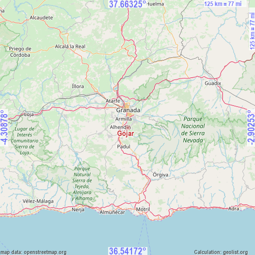
Gójar GPS coordinates[2]
37° 6' 16.416" North, 3° 36' 20.34" West
| Map corner | latitude | longitude |
|---|---|---|
| Upper-left | 37.66325°, | -4.30878° |
| Center: | 37.10456°, | -3.60565° |
| Lower-right: | 36.54172°, | -2.90253° |
| Map W x H: | 124.7×124.7 km | = 77.5×77.5mi |
| max Lat: | 43.74134° ⇑94.8% North |
| Gójar: | 37.10456° |
| min Lat: | ⇓5.2% South 27.64134° |
| min Long | Gójar | max Long |
| -18.00367° | -3.60565° | 4.2899° |
| W 46.3%⇐ | ⇒53.7% E |
Elevation
Elevation of Gójar is 794 m = 2605 ft, and this is 196 m = 643 ft above average elevation for this country.
| Max E: |
1682 m = 5518 ft | 32.7% |
| Gójar | 794 m 2605 ft | |
| Avg. | 598 m = 1962 ft | |
Min E: |
0 m = 0 ft | 67.3% |
See also: Spain elevation on elevation.city.
Geographical zone
Gójar is located in North temperate zone (between Tropic of Cancer and the Arctic Circle). Distance of this Northern Tropic circle is 1519.7 km =944.3 mi to South.| Distance of | km | miles | from Gójar |
|---|---|---|---|
| North Pole | 5881.4 | 3654.5 | to North |
| Arctic Circle | 3275.5 | 2035.3 | to North |
| Tropic Cancer | 1519.7 | 944.3 | to South |
| Equator | 4125.6 | 2563.5 | to South |


Nearby cities:
15 places around Gójar: (largest is in red/bold)
• Alhendín
3.6 km =2.2 mi,  277°
277°
• Armilla
4.7 km =2.9 mi,  338°
338°
• Cenes de la Vega
8.8 km =5.5 mi,  45°
45°
• Churriana de la Vega
5.8 km =3.6 mi,  321°
321°
• Cájar
4.4 km =2.7 mi,  41°
41°
• Cúllar-Vega
7.9 km =4.9 mi,  313°
313°
• Dílar
3.5 km =2.2 mi,  173°
173°
• Granada
9.3 km =5.8 mi,  359°
359°
• Huétor Vega
5.5 km =3.4 mi, 35°
• Las Gabias
6.7 km =4.2 mi,  300°
300°
• Monachil
6.9 km =4.3 mi,  62°
62°
• Ogíjares
1.6 km =1 mi,  353°
353°
• Otura
3 km =1.9 mi,  233°
233°
• Padul
9.1 km =5.7 mi,  191°
191°
• Zubia
2.5 km =1.6 mi, 49°
Sources, notices
• [Note1] Compared only with cities in Spain existing in our database
• [Src1] Map data: © OpenStreetMap contributors (CC-BY-SA)
• [Src2] Other city data from geonames.org with taken over terms of usage.
• [Src3] Geographical zone / Annual Mean Temperature by Robert A. Rohde @ Wikipedia
