Padul geodata
Padul (Andalusia) is a seat of a third-order administrative division; located in Spain in Europe/Madrid (GMT+2) time zone. With population of 7,266 people, there are 1005 cities with bigger population in this country. Compared to other cities in Spain, 95.1% of cities are located further ↑North; 54.2% of cities are located further →East and 63.2% of cities have lower elevation than Padul. Note1


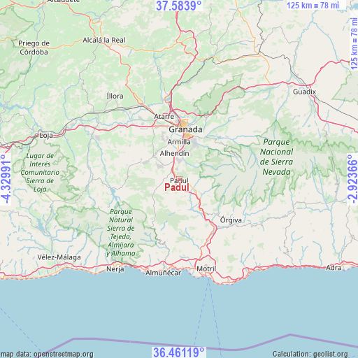
Padul GPS coordinates[2]
37° 1' 28.632" North, 3° 37' 36.408" West
| Map corner | latitude | longitude |
|---|---|---|
| Upper-left | 37.5839°, | -4.32991° |
| Center: | 37.02462°, | -3.62678° |
| Lower-right: | 36.46119°, | -2.92366° |
| Map W x H: | 124.8×124.8 km | = 77.5×77.5mi |
| max Lat: | 43.74134° ⇑95.1% North |
| Padul: | 37.02462° |
| min Lat: | ⇓4.9% South 27.64134° |
| min Long | Padul | max Long |
| -18.00367° | -3.62678° | 4.2899° |
| W 45.8%⇐ | ⇒54.2% E |
Elevation
Elevation of Padul is 766 m = 2513 ft, and this is 168 m = 551 ft above average elevation for this country.
| Max E: |
1682 m = 5518 ft | 36.8% |
| Padul | 766 m 2513 ft | |
| Avg. | 598 m = 1962 ft | |
Min E: |
0 m = 0 ft | 63.2% |
See also: Spain elevation on elevation.city.
Geographical zone
Padul is located in North temperate zone (between Tropic of Cancer and the Arctic Circle). Distance of this Northern Tropic circle is 1510.8 km =938.8 mi to South.| Distance of | km | miles | from Padul |
|---|---|---|---|
| North Pole | 5890.3 | 3660.1 | to North |
| Arctic Circle | 3284.4 | 2040.8 | to North |
| Tropic Cancer | 1510.8 | 938.8 | to South |
| Equator | 4116.8 | 2558.1 | to South |


Nearby cities:
15 places around Padul: (largest is in red/bold)
• Albuñuelas
10.7 km =6.6 mi,  182°
182°
• Alhendín
9.5 km =5.9 mi,  349°
349°
• Armilla
13.3 km =8.3 mi,  0°
0°
• Churriana de la Vega
13.5 km =8.4 mi, 352°
• Cájar
13.1 km =8.1 mi,  21°
21°
• Dílar
5.8 km =3.6 mi, 22°
• Dúrcal
6.8 km =4.2 mi,  127°
127°
• Escúzar
12.6 km =7.8 mi,  289°
289°
• Gójar
9.1 km =5.7 mi,  11°
11°
• Huétor Vega
14.3 km =8.9 mi, 20°
• Las Gabias
12.9 km =8 mi,  342°
342°
• Nigüelas
9.3 km =5.8 mi,  123°
123°
• Ogíjares
10.6 km =6.6 mi, 9°
• Otura
7.1 km =4.4 mi,  355°
355°
• Zubia
11.2 km =7 mi, 19°
Sources, notices
• [Note1] Compared only with cities in Spain existing in our database
• [Src1] Map data: © OpenStreetMap contributors (CC-BY-SA)
• [Src2] Other city data from geonames.org with taken over terms of usage.
• [Src3] Geographical zone / Annual Mean Temperature by Robert A. Rohde @ Wikipedia
