Armilla geodata
Armilla (Andalusia) is a seat of a third-order administrative division; located in Spain in Europe/Madrid (GMT+2) time zone. With population of 21,380 people, there are 446 cities with bigger population in this country. Compared to other cities in Spain, 94.5% of cities are located further ↑North; 54.1% of cities are located further →East and 50.7% of cities have lower elevation than Armilla. Note1


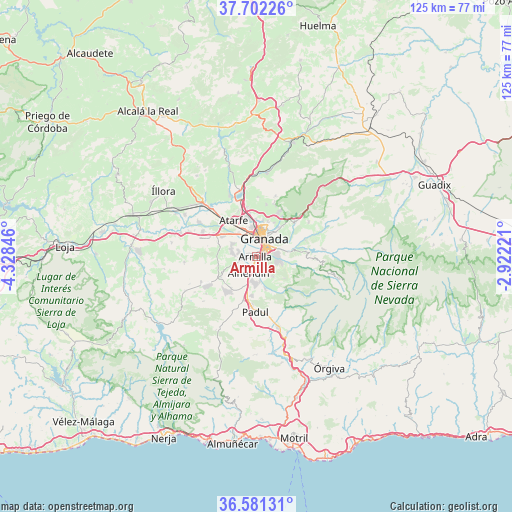
Armilla GPS coordinates[2]
37° 8' 37.896" North, 3° 37' 31.224" West
| Map corner | latitude | longitude |
|---|---|---|
| Upper-left | 37.70226°, | -4.32846° |
| Center: | 37.14386°, | -3.62534° |
| Lower-right: | 36.58131°, | -2.92221° |
| Map W x H: | 124.6×124.6 km | = 77.4×77.4mi |
| max Lat: | 43.74134° ⇑94.5% North |
| Armilla: | 37.14386° |
| min Lat: | ⇓5.5% South 27.64134° |
| min Long | Armilla | max Long |
| -18.00367° | -3.62534° | 4.2899° |
| W 45.9%⇐ | ⇒54.1% E |
Elevation
Elevation of Armilla is 666 m = 2185 ft, and this is 68 m = 223 ft above average elevation for this country.
| Max E: |
1682 m = 5518 ft | 49.3% |
| Armilla | 666 m 2185 ft | |
| Avg. | 598 m = 1962 ft | |
Min E: |
0 m = 0 ft | 50.7% |
See also: Spain elevation on elevation.city.
Geographical zone
Armilla is located in North temperate zone (between Tropic of Cancer and the Arctic Circle). Distance of this Northern Tropic circle is 1524.1 km =947 mi to South.| Distance of | km | miles | from Armilla |
|---|---|---|---|
| North Pole | 5877.1 | 3651.9 | to North |
| Arctic Circle | 3271.2 | 2032.6 | to North |
| Tropic Cancer | 1524.1 | 947 | to South |
| Equator | 4130 | 2566.3 | to South |


Nearby cities:
15 places around Armilla: (largest is in red/bold)
• Alhendín
4.3 km =2.7 mi,  204°
204°
• Cenes de la Vega
8.2 km =5.1 mi,  77°
77°
• Churriana de la Vega
1.9 km =1.2 mi,  273°
273°
• Cájar
4.8 km =3 mi,  103°
103°
• Cúllar-Vega
4.2 km =2.6 mi,  285°
285°
• Dílar
8.2 km =5.1 mi,  164°
164°
• Granada
5.2 km =3.2 mi,  18°
18°
• Gójar
4.7 km =2.9 mi, 158°
• Huétor Vega
4.9 km =3 mi,  88°
88°
• Las Gabias
4.1 km =2.5 mi,  256°
256°
• Maracena
7.1 km =4.4 mi,  353°
353°
• Monachil
7.9 km =4.9 mi, 98°
• Ogíjares
3.2 km =2 mi,  150°
150°
• Otura
6.2 km =3.9 mi,  186°
186°
• Zubia
4.6 km =2.9 mi,  126°
126°
Sources, notices
• [Note1] Compared only with cities in Spain existing in our database
• [Src1] Map data: © OpenStreetMap contributors (CC-BY-SA)
• [Src2] Other city data from geonames.org with taken over terms of usage.
• [Src3] Geographical zone / Annual Mean Temperature by Robert A. Rohde @ Wikipedia
