Las Gabias geodata
Las Gabias (Andalusia) is a seat of a third-order administrative division; located in Spain in Europe/Madrid (GMT+2) time zone. With population of 16,369 people, there are 575 cities with bigger population in this country. Compared to other cities in Spain, 94.6% of cities are located further ↑North; 54.8% of cities are located further →East and 52.6% of cities have lower elevation than Las Gabias. Note1


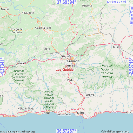
Las Gabias GPS coordinates[2]
37° 8' 7.728" North, 3° 40' 13.044" West
| Map corner | latitude | longitude |
|---|---|---|
| Upper-left | 37.69394°, | -4.37341° |
| Center: | 37.13548°, | -3.67029° |
| Lower-right: | 36.57287°, | -2.96716° |
| Map W x H: | 124.7×124.7 km | = 77.5×77.5mi |
| max Lat: | 43.74134° ⇑94.6% North |
| Las Gabias: | 37.13548° |
| min Lat: | ⇓5.4% South 27.64134° |
| min Long | Las Gabias | max Long |
| -18.00367° | -3.67029° | 4.2899° |
| W 45.2%⇐ | ⇒54.8% E |
Elevation
Elevation of Las Gabias is 686 m = 2251 ft, and this is 88 m = 289 ft above average elevation for this country.
| Max E: |
1682 m = 5518 ft | 47.4% |
| Las Gabias | 686 m 2251 ft | |
| Avg. | 598 m = 1962 ft | |
Min E: |
0 m = 0 ft | 52.6% |
See also: Spain elevation on elevation.city.
Geographical zone
Las Gabias is located in North temperate zone (between Tropic of Cancer and the Arctic Circle). Distance of this Northern Tropic circle is 1523.2 km =946.5 mi to South.| Distance of | km | miles | from Las Gabias |
|---|---|---|---|
| North Pole | 5878 | 3652.4 | to North |
| Arctic Circle | 3272.1 | 2033.2 | to North |
| Tropic Cancer | 1523.2 | 946.5 | to South |
| Equator | 4129.1 | 2565.7 | to South |


Nearby cities:
15 places around Las Gabias: (largest is in red/bold)
• Alhendín
3.7 km =2.3 mi,  143°
143°
• Armilla
4.1 km =2.5 mi,  76°
76°
• Atarfe
10 km =6.2 mi,  351°
351°
• Churriana de la Vega
2.4 km =1.5 mi,  63°
63°
• Cájar
8.6 km =5.3 mi,  91°
91°
• Cúllar-Vega
2 km =1.2 mi,  358°
358°
• Dílar
9.3 km =5.8 mi, 138°
• Granada
8.1 km =5 mi,  43°
43°
• Gójar
6.7 km =4.2 mi,  120°
120°
• Huétor Vega
9 km =5.6 mi, 83°
• Maracena
8.6 km =5.3 mi,  21°
21°
• Ogíjares
5.8 km =3.6 mi,  108°
108°
• Otura
6.2 km =3.9 mi,  147°
147°
• Santafé
7.3 km =4.5 mi,  323°
323°
• Zubia
7.9 km =4.9 mi,  103°
103°
Sources, notices
• [Note1] Compared only with cities in Spain existing in our database
• [Src1] Map data: © OpenStreetMap contributors (CC-BY-SA)
• [Src2] Other city data from geonames.org with taken over terms of usage.
• [Src3] Geographical zone / Annual Mean Temperature by Robert A. Rohde @ Wikipedia
