Cúllar-Vega geodata
Cúllar-Vega (Andalusia) is a populated place; located in Spain in Europe/Madrid (GMT+2) time zone. With population of 5,487 people, there are 1216 cities with bigger population in this country. Compared to other cities in Spain, 94.5% of cities are located further ↑North; 54.9% of cities are located further →East and 51.5% of cities have higher elevation than Cúllar-Vega. Note1


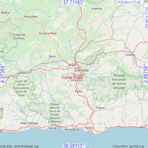
Cúllar-Vega GPS coordinates[2]
37° 9' 12.996" North, 3° 40' 14.592" West
| Map corner | latitude | longitude |
|---|---|---|
| Upper-left | 37.71193°, | -4.37384° |
| Center: | 37.15361°, | -3.67072° |
| Lower-right: | 36.59113°, | -2.96759° |
| Map W x H: | 124.6×124.6 km | = 77.4×77.4mi |
| max Lat: | 43.74134° ⇑94.5% North |
| Cúllar-Vega: | 37.15361° |
| min Lat: | ⇓5.5% South 27.64134° |
| min Long | Cúllar-Vega | max Long |
| -18.00367° | -3.67072° | 4.2899° |
| W 45.1%⇐ | ⇒54.9% E |
Elevation
Elevation of Cúllar-Vega is 643 m = 2110 ft, and this is 45 m = 148 ft above average elevation for this country.
| Max E: |
1682 m = 5518 ft | 51.5% |
| Cúllar-Vega | 643 m 2110 ft | |
| Avg. | 598 m = 1962 ft | |
Min E: |
0 m = 0 ft | 48.5% |
See also: Spain elevation on elevation.city.
Geographical zone
Cúllar-Vega is located in North temperate zone (between Tropic of Cancer and the Arctic Circle). Distance of this Northern Tropic circle is 1525.2 km =947.7 mi to South.| Distance of | km | miles | from Cúllar-Vega |
|---|---|---|---|
| North Pole | 5876 | 3651.2 | to North |
| Arctic Circle | 3270.1 | 2031.9 | to North |
| Tropic Cancer | 1525.2 | 947.7 | to South |
| Equator | 4131.1 | 2566.9 | to South |


Nearby cities:
15 places around Cúllar-Vega: (largest is in red/bold)
• Albolote
8.7 km =5.4 mi,  9°
9°
• Alhendín
5.5 km =3.4 mi,  155°
155°
• Armilla
4.2 km =2.6 mi,  105°
105°
• Atarfe
8 km =5 mi,  349°
349°
• Churriana de la Vega
2.4 km =1.5 mi, 113°
• Cájar
9 km =5.6 mi,  104°
104°
• Granada
6.9 km =4.3 mi,  55°
55°
• Gójar
7.9 km =4.9 mi,  133°
133°
• Huétor Vega
9 km =5.6 mi, 95°
• Las Gabias
2 km =1.2 mi,  178°
178°
• Maracena
6.8 km =4.2 mi,  27°
27°
• Ogíjares
6.8 km =4.2 mi,  124°
124°
• Otura
8 km =5 mi, 155°
• Santafé
5.8 km =3.6 mi,  312°
312°
• Zubia
8.6 km =5.3 mi, 116°
Sources, notices
• [Note1] Compared only with cities in Spain existing in our database
• [Src1] Map data: © OpenStreetMap contributors (CC-BY-SA)
• [Src2] Other city data from geonames.org with taken over terms of usage.
• [Src3] Geographical zone / Annual Mean Temperature by Robert A. Rohde @ Wikipedia
