Alhendín geodata
Alhendín (Andalusia) is a seat of a third-order administrative division; located in Spain in Europe/Madrid (GMT+2) time zone. With population of 4,899 people, there are 1328 cities with bigger population in this country. Compared to other cities in Spain, 94.8% of cities are located further ↑North; 54.5% of cities are located further →East and 58.9% of cities have lower elevation than Alhendín. Note1


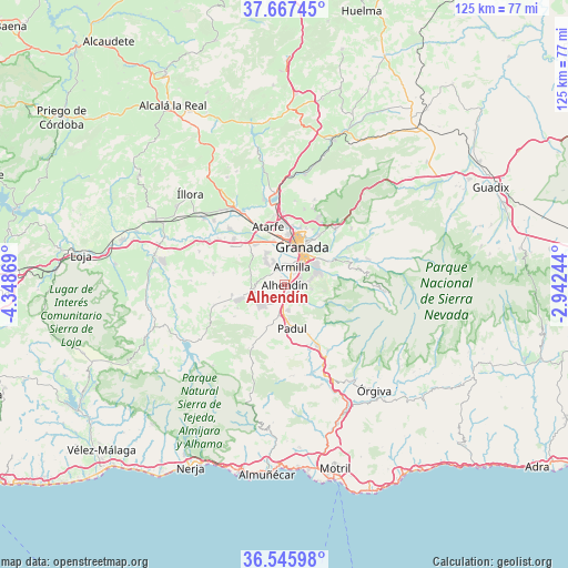
Alhendín GPS coordinates[2]
37° 6' 31.644" North, 3° 38' 44.052" West
| Map corner | latitude | longitude |
|---|---|---|
| Upper-left | 37.66745°, | -4.34869° |
| Center: | 37.10879°, | -3.64557° |
| Lower-right: | 36.54598°, | -2.94244° |
| Map W x H: | 124.7×124.7 km | = 77.5×77.5mi |
| max Lat: | 43.74134° ⇑94.8% North |
| Alhendín: | 37.10879° |
| min Lat: | ⇓5.2% South 27.64134° |
| min Long | Alhendín | max Long |
| -18.00367° | -3.64557° | 4.2899° |
| W 45.5%⇐ | ⇒54.5% E |
Elevation
Elevation of Alhendín is 736 m = 2415 ft, and this is 138 m = 453 ft above average elevation for this country.
| Max E: |
1682 m = 5518 ft | 41.1% |
| Alhendín | 736 m 2415 ft | |
| Avg. | 598 m = 1962 ft | |
Min E: |
0 m = 0 ft | 58.9% |
See also: Spain elevation on elevation.city.
Geographical zone
Alhendín is located in North temperate zone (between Tropic of Cancer and the Arctic Circle). Distance of this Northern Tropic circle is 1520.2 km =944.6 mi to South.| Distance of | km | miles | from Alhendín |
|---|---|---|---|
| North Pole | 5881 | 3654.3 | to North |
| Arctic Circle | 3275.1 | 2035.1 | to North |
| Tropic Cancer | 1520.2 | 944.6 | to South |
| Equator | 4126.1 | 2563.8 | to South |


Nearby cities:
15 places around Alhendín: (largest is in red/bold)
• Armilla
4.3 km =2.7 mi,  24°
24°
• Churriana de la Vega
4 km =2.5 mi,  359°
359°
• Cájar
7 km =4.3 mi,  66°
66°
• Cúllar-Vega
5.5 km =3.4 mi,  335°
335°
• Dílar
5.6 km =3.5 mi,  135°
135°
• Granada
9.5 km =5.9 mi, 21°
• Gójar
3.6 km =2.2 mi,  97°
97°
• Huétor Vega
7.9 km =4.9 mi,  58°
58°
• Las Gabias
3.7 km =2.3 mi,  323°
323°
• Maracena
11 km =6.8 mi,  4°
4°
• Monachil
10 km =6.2 mi, 74°
• Ogíjares
3.5 km =2.2 mi, 71°
• Otura
2.5 km =1.6 mi,  154°
154°
• Padul
9.5 km =5.9 mi,  169°
169°
• Zubia
5.6 km =3.5 mi,  78°
78°
Sources, notices
• [Note1] Compared only with cities in Spain existing in our database
• [Src1] Map data: © OpenStreetMap contributors (CC-BY-SA)
• [Src2] Other city data from geonames.org with taken over terms of usage.
• [Src3] Geographical zone / Annual Mean Temperature by Robert A. Rohde @ Wikipedia
