Garrovillas geodata
Garrovillas (Extremadura) is a populated place; located in Spain in Europe/Madrid (GMT+2) time zone. With population of 2,390 people, there are 1947 cities with bigger population in this country. Compared to other cities in Spain, 74.2% of cities are located further ↑North; 91.6% of cities are located further →East and 73.2% of cities have higher elevation than Garrovillas. Note1
Administrative division(s):
- Level 1: Extremadura
- Level 2: Provincia de Cáceres
- Level 3: Garrovillas de Alconétar


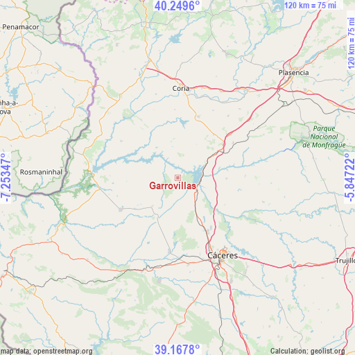
Garrovillas GPS coordinates[2]
39° 42' 38.952" North, 6° 33' 1.224" West
| Map corner | latitude | longitude |
|---|---|---|
| Upper-left | 40.2496°, | -7.25347° |
| Center: | 39.71082°, | -6.55034° |
| Lower-right: | 39.1678°, | -5.84722° |
| Map W x H: | 120.3×120.3 km | = 74.8×74.8mi |
| max Lat: | 43.74134° ⇑74.2% North |
| Garrovillas: | 39.71082° |
| min Lat: | ⇓25.8% South 27.64134° |
| min Long | Garrovillas | max Long |
| -18.00367° | -6.55034° | 4.2899° |
| W 8.4%⇐ | ⇒91.6% E |
Elevation
Elevation of Garrovillas is 328 m = 1076 ft, and this is 270 m = 886 ft below average elevation for this country.
| Max E: |
1682 m = 5518 ft | 73.2% |
| Avg. | 598 m = 1962 ft | |
| Garrovillas | 328 m = 1076 ft | |
Min E: |
0 m = 0 ft | 26.8% |
See also: Spain elevation on elevation.city.
Geographical zone
Garrovillas is located in North temperate zone (between Tropic of Cancer and the Arctic Circle). Distance of this Northern Tropic circle is 1809.5 km =1124.4 mi to South.| Distance of | km | miles | from Garrovillas |
|---|---|---|---|
| North Pole | 5591.6 | 3474.5 | to North |
| Arctic Circle | 2985.7 | 1855.2 | to North |
| Tropic Cancer | 1809.5 | 1124.4 | to South |
| Equator | 4415.4 | 2743.6 | to South |


Nearby cities:
15 places around Garrovillas: (largest is in red/bold)
• Acehuche
12.4 km =7.7 mi,  325°
325°
• Brozas
22.3 km =13.9 mi,  240°
240°
• Casar de Cáceres
20.1 km =12.5 mi,  146°
146°
• Casas de Millán
22.3 km =13.9 mi,  57°
57°
• Cañaveral
16.3 km =10.1 mi, 56°
• Ceclavín
22.7 km =14.1 mi,  303°
303°
• Hinojal
16.7 km =10.4 mi,  90°
90°
• Mata de Alcántara
22.9 km =14.2 mi,  271°
271°
• Navas del Madroño
13.1 km =8.1 mi,  221°
221°
• Pedroso de Acim
17.3 km =10.7 mi,  42°
42°
• Portaje
23 km =14.3 mi,  357°
357°
• Portezuelo
13 km =8.1 mi,  29°
29°
• Santiago del Campo
18.4 km =11.4 mi,  119°
119°
• Talaván
23 km =14.3 mi, 88°
• Torrejoncillo
21.9 km =13.6 mi,  18°
18°
Sources, notices
• [Note1] Compared only with cities in Spain existing in our database
• [Src1] Map data: © OpenStreetMap contributors (CC-BY-SA)
• [Src2] Other city data from geonames.org with taken over terms of usage.
• [Src3] Geographical zone / Annual Mean Temperature by Robert A. Rohde @ Wikipedia
